Cabo de Gata
| Cabo de Gata-Níjar | |
|---|---|
|
IUCN category V (protected landscape/seascape)
|
|

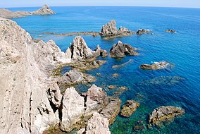
Arrecife de las Sirenas
|
|
| Location | Spain |
| Nearest city | Almería |
| Coordinates | 36°47′00″N 02°06′00″W / 36.78333°N 2.10000°WCoordinates: 36°47′00″N 02°06′00″W / 36.78333°N 2.10000°W |
| Area | 460 km2 |
| Established | 1997 |
| Visitors | 500,000 (in 1998) |
| Governing body | Junta de Andalucia |
| Official name | Salinas del Cabo de Gata |
| Designated | December 5, 1989 |
Cabo de Gata-Níjar Natural Park in the southeastern corner of Spain, is Andalucia's largest coastal protected area, a wild and isolated landscape with some of Europe's most original geological features. It is the only region in Europe with a true hot desert climate (Köppen climate classification: BWh).
The eponymous mountain range of the Sierra del Cabo de Gata with its highest peak El Fraile is Spain's largest volcanic rock formation with sharp peaks and crags in red and ochre-hues. It falls steeply to the Mediterranean Sea creating jagged 100-metre (330 ft) high cliffs, which are riven by gullies leading to hidden coves with white sandy beaches, some of the most beautiful in Andalucia.
Offshore are numerous tiny rocky islands and underwater extensive coral reefs teeming with marine life. Its climate is arid to the extent of being the driest location in Europe and the continent´s only subtropical or "warm" desert, with rainfall below 200 mm (7.9 in) a year and average yearly temperatures above 18 °C (64 °F). In 1997 it was designated as a UNESCO Biosphere Reserve. In 2001 it was included among the Specially Protected Areas of Mediterranean Importance. In 2010 it was proposed as a dump for nuclear waste.
The name 'Cabo de Gata relates to the mineral agate that used to be mined in this area.
Cabo de Gata-Níjar Natural Park is characterised by volcanic rock formations - lava flows, volcanic domes, volcanic calderas. The park joined UNESCO's Global Geoparks Network in 2006, and is also a member of the European Geoparks Network.
...
Wikipedia

