Córdoba, Veracruz
| Córdoba | ||
|---|---|---|
| City | ||

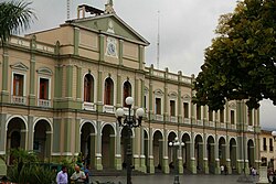
Municipal Palace of Córdoba
|
||
|
||
| Nickname(s): The City of the Thirty Knights | ||
| Coordinates: 18°53′39″N 96°56′05″W / 18.89417°N 96.93472°W | ||
| Country |
|
|
| State | Veracruz | |
| Municipality | Córdoba | |
| Founded | April 27, 1618 | |
| Government | ||
| • Municipal president | Tomas Rios Bernal | |
| Area | ||
| • Total | 226 km2 (87 sq mi) | |
| Time zone | CST (UTC-6) | |
| Postal code | 94500 | |
| Website | [1] | |
Córdoba, officially known as Heroica Córdoba, is a city and the seat of the municipality of the same name in the Mexican state of Veracruz. It was founded in 1618.
The city is composed of 15 barrios,(Neighborhoods) bounded to the north by Ixhuatlán del Café and Tomatlán, and to the south by Amatlán de los Reyes and Naranjal. The eastern area abuts Fortin de las Flores and Chocamán and the western area borders Amatlán de los Reyes.
Córdoba has a municipal area of 226 km.2 It is divided into 176 localities, of which the most important are San José de Tapia, las Flores, Miraflores, Los Naranjos, Brillante Crucero, el Porvenir, San Rafael Caleria, Santa Elena, San Miguelito, and San Nicolás.
Córdoba is located in the center of the state of Veracruz, at 18º51'30" north latitude and 96º55'51" west longitude. It lies between the hills of Matlaquiahitl and Tepixtepec, at an elevation of 817 meters above mean sea level.
Its climate is warm and humid, with an annual average temperature of 19.8 °C. There is abundant rainfall in summer and autumn, with little rain in winter.
The village of Córdoba was founded in 1618 by the Spanish to protect royal interests from attacks by Gaspar Yanga's slave rebellion.
In August 1821, the Mexican revolutionary Agustín de Iturbide and the Spanish viceroy Juan de O'Donojú signed the Treaty of Córdoba here, ratifying the Plan de Iguala and confirming Mexico's independence.
In 1902 Córdoba became the interchange point of the narrow-gauge Córdoba and Huatusco Railroad to Coscomatepec.
...
Wikipedia


