Butler Township, Luzerne County, Pennsylvania
| Butler Township, Luzerne County, Pennsylvania |
|
|---|---|
| Township | |

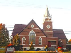
St. John's Lutheran Church on St. John's Road
|
|
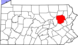
 Map of Luzerne County, Pennsylvania Highlighting Butler Township |
|
 Map of Luzerne County, Pennsylvania |
|
| Country | United States |
| State | Pennsylvania |
| County | Luzerne |
| Area | |
| • Total | 33.6 sq mi (87.1 km2) |
| • Land | 33.4 sq mi (86.4 km2) |
| • Water | 0.3 sq mi (0.7 km2) |
| Population (2010) | |
| • Total | 9,221 |
| • Density | 270/sq mi (110/km2) |
| Time zone | Eastern (EST) (UTC-5) |
| • Summer (DST) | EDT (UTC-4) |
| Website | butler-township |
Butler Township is a township in Luzerne County, Pennsylvania, United States. The population was 9,221 at the 2010 census.
The Luzerne County Fresh Air Camp was listed on the National Register of Historic Places in 2004.
According to the United States Census Bureau, the township has a total area of 33.6 square miles (87.1 km2), of which 33.4 square miles (86.4 km2) is land and 0.27 square miles (0.7 km2), or 0.75%, is water. It is drained by Nescopeck Creek westward into the Susquehanna River. It is located mainly in the Sugarloaf Valley between Nescopeck Mountain to the north and Buck Mountain to the south. Its villages include Beech Mountain Lakes, Drums, Edgewood, Kis-Lyn, Nescopeck Pass (also in Dorrance Township), St. Johns, and Sand Spring.
As of the census of 2000, there were 7,166 people, 2,523 households, and 1,899 families residing in the township. The population density was 215.2 people per square mile (83.1/km2). There were 2,747 housing units at an average density of 82.5/sq mi (31.9/km2). The racial makeup of the township was 92.69% White, 5.67% African American, 0.15% Native American, 0.50% Asian, 0.01% Pacific Islander, 0.39% from other races, and 0.59% from two or more races. Hispanic or Latino of any race were 1.79% of the population.
...
Wikipedia
