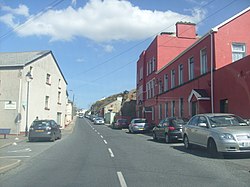
Burtonport
|
Ailt an Chorráin Burtonport |
|
|---|---|
| Town | |
 |
|
| Location in Ireland | |
| Coordinates: 54°58′56″N 8°26′04″W / 54.982293°N 8.434324°WCoordinates: 54°58′56″N 8°26′04″W / 54.982293°N 8.434324°W | |
| Country | Ireland |
| Province | Ulster |
| County | County Donegal |
| Government | |
| • Dáil Éireann | Donegal South-West |
| Population (2011) | |
| • Total | 323 |
| Irish Grid Reference | B717154 |
| As this is a Gaeltacht village, the Irish Ailt an Chorráin is the only official name. | |
Ailt an Chorráin or Ailt a' Chorráin (English name: Burtonport) is a Gaeltacht fishing village about 7 km northwest of Dungloe in The Rosses area of County Donegal, Ireland.
The main employers in the village are the Burtonport Fishermen's Co-op and the Bord Iascaigh Mhara (Irish Sea Fisheries Board) ice plant. In recent years these establishments have been in decline due to the abandonment of fishing as a career and way of life by locals, due to depleted fish stocks and very restrictive fishing laws.
A plaque there commemorates the brief landing on the nearby island of Inishmacadurn (or Rutland Island) of a French military force led by James Napper Tandy in a failed attempt to assist rebels during the 1798 rebellion on 16 September 1798.
As the mainland port for both the Arranmore car ferry service and the Arranmore fast ferry passenger service, Burtonport receives a lot of passing tourist traffic.
Burtonport had a railway service from Letterkenny between 1903 and 1940 provided by the Letterkenny & Burtonport Extension Railway (L&BER), a company jointly owned by the State and the Londonderry and Lough Swilly Railway (L&LSR). Burtonport railway station opened on 9 March 1903, but finally closed on 3 June 1940.
...
Wikipedia

