Burgh and Tuttington
| Burgh and Tuttington | |
|---|---|
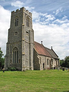
 St Mary at Burgh next Aylsham |
|
| Burgh and Tuttington shown within Norfolk | |
| Area | 6.70 km2 (2.59 sq mi) |
| Population | 322 (2011) |
| • Density | 48/km2 (120/sq mi) |
| OS grid reference | TG224262 |
| Civil parish |
|
| District | |
| Shire county | |
| Region | |
| Country | England |
| Sovereign state | United Kingdom |
| Post town | NORWICH |
| Postcode district | NR11 |
| Police | Norfolk |
| Fire | Norfolk |
| Ambulance | East of England |
| EU Parliament | East of England |
Burgh and Tuttington is a civil parish in the English county of Norfolk. It covers an area of 6.70 km2 (2.59 sq mi) and had a population of 255 in 115 households at the 2001 census, increasing to a population of 322 in 140 households at the 2011 Census. For the purposes of local government, it falls within the district of Broadland. The parish includes Burgh next Aylsham and Tuttington.
Burgh next Aylsham has a grade I listed church dedicated to Mary, which features a notable fifteenth-century baptismal font. The church was restored in the late nineteenth century by Richard Phipson.
Tuttington church of SS Peter and Paul is a grade II* listed building.
Burgh Mill is a large Grade II* listed water mill dating from the early 18th century but greatly enlarged in the late 18th century and early 19th century. The basic machinery is probably early 19th century. It is built in 3 storeys with an attic from a clapboarded timber frame with some colour-washed brick to lower storey and internally. The roofs are pantile and some corrugated iron.
...
Wikipedia

