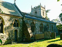
Burbage, Wiltshire
| Burbage | |
|---|---|
 All Saints' church, Burbage |
|
| Burbage shown within Wiltshire | |
| Population | 1,772 (in 2011) |
| OS grid reference | SU2361 |
| Civil parish |
|
| Unitary authority | |
| Ceremonial county | |
| Region | |
| Country | England |
| Sovereign state | United Kingdom |
| Post town | Marlborough |
| Postcode district | SN8 |
| Dialling code | 01672 |
| Police | Wiltshire |
| Fire | Dorset and Wiltshire |
| Ambulance | South Western |
| EU Parliament | South West England |
| UK Parliament | |
| Website | Parish Council |
Burbage is a village and civil parish in the Vale of Pewsey, Wiltshire, England. It is about 6 miles (9.7 km) south of Marlborough and 20 miles (32 km) west of Newbury.
The parish includes the hamlets of Durley, Eastcourt, Marr Green, Ram Alley, Stibb Green, The Warren (which is close to Tottenham House), and Westcourt.
Burbage is a civil parish with an elected parish council. It is in the area of Wiltshire Council unitary authority. Both councils are responsible for different aspects of local government.
The parish is part of the 'Burbage and the Bedwyns' electoral ward. The ward starts in the north at Little Bedwyn, stretches to Great Bedwyn and Shalbourne then extends west to Grafton and Burbage. The population of the ward taken at the 2011 census was 4,829.
Burbage stands on a watershed at the eastern end of the Vale of Pewsey, with streams to the east draining to the Thames via the Dun and Kennet; to the south draining to the Salisbury Avon via the River Bourne; and to the north and west direct to the Avon.
The village High Street was the main north-south road from Marlborough to Andover, now the A346 primary route, until a bypass was built to the west in 1991. A more minor route from Pewsey to Hungerford and the M4 (designated A338 to the east and B3087 to the west) passes to the south of the village. Burbage no longer has a station on the nearby Reading to Taunton line, the nearest stations being at Great Bedwyn (which has commuter services to London) and Pewsey.
...
Wikipedia

