Bung Kan
|
Bueng Kan บึงกาฬ |
|
|---|---|
| Township | |
| Coordinates: 18°22′2″N 103°38′59″E / 18.36722°N 103.64972°E | |
| Country | Thailand |
| Province | Bueng Kan |
| Amphoe | Mueang Bueng Kan |
| Population (2010) | |
| • Total | 9,712 |
| Time zone | ICT (UTC+7) |
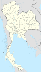
Bueng Kan (Thai: บึงกาฬ) is a township (Thesaban Tambon) in Mueang Bueng Kan District, in Bueng Kan Province, far northeastern Thailand. It is the district capital and is on the Mekong River, opposite the Laotian town of Pakxan of Bolikhamsai Province. As of 2010, it had a population of 9,712 people and has jurisdiction over 11 villages. It lies at the junction of Highways 212 and 222, 136 kilometres northeast of Nong Khai and 750 kilometres northeast of Bangkok. The economy is based on agriculture, with para rubber as the principal crop, and tourism.
The settlement became a sanitary district in 1956. Like all sanitary districts, it was upgraded to sub-district municipality in 1999.
Bueng Kan was formerly part of Nong Khai Province until the formal establishment of the new province of the same name on 23 March 2011.
Bueng (บึง) means marsh; Kan (กาฬ) is associated with the Hindu deity Kāla, or the colour black.
As of 1998, a reported seventeen buses a day make the two-hour journey from Nong Khai to Bueng Kan along Thailand Route 222, seven of which continue to Nakhon Phanom.
...
Wikipedia

