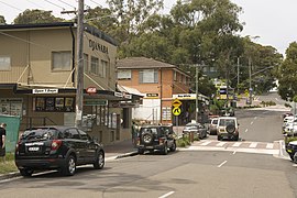
Bundeena
|
Bundeena Sydney, New South Wales |
|||||||||||||
|---|---|---|---|---|---|---|---|---|---|---|---|---|---|

Town centre, November 2009
|
|||||||||||||
| Coordinates | 34°5′17.02″S 151°9′14.62″E / 34.0880611°S 151.1540611°ECoordinates: 34°5′17.02″S 151°9′14.62″E / 34.0880611°S 151.1540611°E | ||||||||||||
| Population | 1,894 (2011 census) | ||||||||||||
| • Density | 997/km2 (2,580/sq mi) | ||||||||||||
| Postcode(s) | 2230 | ||||||||||||
| Area | 1.9 km2 (0.7 sq mi) | ||||||||||||
| Location | 29 km (18 mi) south of Sydney CBD | ||||||||||||
| LGA(s) | Sutherland Shire | ||||||||||||
| State electorate(s) | Heathcote | ||||||||||||
| Federal Division(s) | Hughes | ||||||||||||
|
|||||||||||||
Bundeena is a village on the outskirts of southern Sydney, in the state of New South Wales, Australia. Bundeena is located 29 km south of the Sydney central business district and is part of the local government area of the Sutherland Shire.
Bundeena is adjacent to the village of Maianbar and lies on the southern side of Port Hacking, opposite the suburbs of Cronulla and Burraneer. The village is surrounded by the Royal National Park.
The beaches at Bundeena are Jibbon Beach, Gunyah Beach, Horderns Beach and Bonnie Vale Beach. Cabbage Tree Creek and 'The Basin' separate Bundeena from the smaller village of Maianbar. A bush track and footbridge link the two villages. Bonnie Vale is also one of the few camp grounds within the Royal National Park.
Bundeena may be reached by passenger ferry from Cronulla or by road through the Royal National Park from Sutherland or Waterfall. Cronulla and National Park Ferry Cruises provides regular ferry services between Cronulla and Bundeena. The wharf at Cronulla is located on Gunnamatta Bay, near Cronulla railway station. Ferry trips vary from 20 minutes to 30 minutes depending on the weather. Many people from Bundeena drive to the railway station at Sutherland, as it is only a 25-minute drive as opposed to 30 minutes by ferry to Cronulla and then a 15-minute train trip to Sutherland.
...
Wikipedia

