Bulford
| Bulford | |
|---|---|
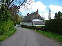
 Old Coach Road, Bulford |
|
| Bulford shown within Wiltshire | |
| Population | 4,201 (in 2011) |
| OS grid reference | SU168434 |
| Civil parish |
|
| Unitary authority | |
| Ceremonial county | |
| Region | |
| Country | England |
| Sovereign state | United Kingdom |
| Post town | Salisbury |
| Postcode district | SP4 |
| Dialling code | 01980 |
| Police | Wiltshire |
| Fire | Dorset and Wiltshire |
| Ambulance | South Western |
| EU Parliament | South West England |
| UK Parliament | |
| Website | Parish Council |
Bulford is a village and civil parish in Wiltshire, England, close to Salisbury Plain. The village is close to Durrington and about 1.5 miles (2.4 km) north of the town of Amesbury. The Bulford Camp army base is separate from the village but within the parish.
The Salisbury Avon forms the western boundary of the parish, and the village is near the confluence of the Nine Mile River with the Avon.
The Bulford Kiwi a large chalk representation of a kiwi on the hill above the village.
Evidence of occupation of the area in the late Neolithic era is provided by many round barrows on the downs. A Bronze Age boundary ditch is in the northeast of the parish.
The 1086 Domesday Book recorded 39 households at Bulford, within an estate of Amesbury Abbey.
The name is derived from the Old English bulut ieg ford meaning 'ragged robin island ford'. It is recorded in the Wiltshire Charter Rolls of 1199 as Bultiford and as Bultesforda in 1270. It is then recorded as Bulteforde in the Ecclesiastical Tax Records of 1291.
From 1897, land east of Bulford began to be used by the Army as Bulford Camp. In 1906 the Amesbury and Military Camp Light Railway was extended from Amesbury into the camp and a station was provided at Bulford, on the southern edge of the village where the line crossed the road which is now the A3028. The line closed to passengers in 1952 but goods services continued until 1963.
The civil parish elects a parish council. It is in the area of Wiltshire Council, a unitary authority which is responsible for most local government functions.
...
Wikipedia

