Bukit Barisan Selatan National Park
| Bukit Barisan Selatan National Park | |
|---|---|
| Taman Nasional Bukit Barisan Selatan | |
|
IUCN category II (national park)
|
|
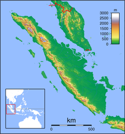
| Location | Sumatra, Indonesia |
| Coordinates | 5°26′S 104°20′E / 5.433°S 104.333°ECoordinates: 5°26′S 104°20′E / 5.433°S 104.333°E |
| Area | 356,800 hectares (882,000 acres; 3,568 km2) |
| Established | 1982 |
| Governing body | Ministry of Environment and Forestry |
| World Heritage Site | 2004 |
| Official name | Tropical Rainforest Heritage of Sumatra |
| Type | Natural |
| Criteria | vii, ix, x |
| Designated | 2004 (28th session) |
| Reference no. | 1167 |
| State Party | Indonesia |
| Region | Asia-Pacific |
| Endangered | 2011–present |
Bukit Barisan Selatan National Park is a national park in Sumatra, Indonesia. The park located along the Bukit Barisan mountain range, has a total area of 3,568 km2, and spans three provinces: Lampung, Bengkulu, and South Sumatra. Together with Gunung Leuser and Kerinci Seblat national parks it forms a World Heritage Site, Tropical Rainforest Heritage of Sumatra.
The national park stretching along the Bukit Barisan mountain range is in average only 45 km wide but 350 km long. The northern part is mountainous with its highest point at Gunung Pulung (1,964 m), while its southern section is a peninsula. It is covered by montane forest, lowland tropical forest, coastal forest and mangrove forest.
Plants in the park include Nipa palm, Casuarina equisetifolia, Anisoptera curtisii and Gonystylus bancanus, as well as Sonneratia, Pandanus, Shorea and Dipterocarpus species. Large flowers in the park include the Rafflesia arnoldii, Amorphophallus decus-silvae, Amorphophallus titanum and the world's largest orchid the Grammatophyllum speciosum.
The park is home to many endangered and threatened species, including:
...
Wikipedia

