Budhabare, Mechi
|
Hadiya Budhabare हडिया बुधवारे |
|
|---|---|
| Village Development Committee | |

A bird's eye view of part of Budhabare village
|
|
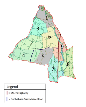
 Map of Budhabare depicting the constituent wards |
|
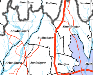
 Zoomed-in map of Jhapa district with Budhabare at the center and adjacent geographic entities around it |
|
| Location in Nepal | |
| Coordinates: 26°43′26″N 88°03′01″E / 26.723838°N 88.050179°ECoordinates: 26°43′26″N 88°03′01″E / 26.723838°N 88.050179°E | |
| Country |
|
| Province | Province No. 1 |
| Zone | Mechi |
| District | Jhapa |
| Area | |
| • Total | 31.73 km2 (12.25 sq mi) |
| Highest elevation | 329 m (1,079 ft) |
| Lowest elevation | 149 m (489 ft) |
| Population (2011) | |
| • Total | 22,936 |
| • Density | 722.85/km2 (1,872.2/sq mi) |
| • Ethnicities | Brahmin, Chhetri, Kami, Limbu, Rai |
| Demonym(s) | Budhabarebasi |
| Time zone | NST (UTC+5:45) |
| A.P.O. | 57206 |
| PSTN | 555 |
Budhabare, more specifically Hadiya Budhabare, is a former Village Development Committee in the northern part of Jhapa district of Mechi zone in south-eastern Nepal. Under the new federal division, the VDC lies in Province No. 1. The latest official data, 2011 Nepal Census, puts the total population of the VDC at 22,936. Owing to this average population size, the VDC has been divided into nine wards.
As the village is crossed by Hadiya Khola, it is sometimes also referred to as Hadiya Budhabare. The village of Budhabare is best known for two things: the production of betelnut and the market that is held every Wednesday. The market of Budhabare grew in importance tremendously after the highway to Ilam was constructed, as Budhabare now lies along the Mechi Highway, which connects all the districts of Mechi zone.
The origin of the name budhabare dates back to the early 1940s. Local legend has it that, at that time, an elite man by the name of Nandalal Acharya began to organize a weekly market day, or hatiya, in the village. This followed a similar trend that was already in practice on Saturday in Sanischare, on Sunday in Aaitabare, on Friday and Monday in Dhulabari, and on Thursday in Phikkal. Out of fears that a concurrent market day would be detrimental and challenging to business, they decided go with either Tuesday or Wednesday. As Tuesday is generally considered a kharobar, or brute day, in Nepali culture, Wednesday became the pick. Over time, the village came to be known after this day of the market as Budhabare, since Budhabar is the Nepali term for Wednesday. This market, which started off in the early 1940s, still continues to this day and has become a major attraction of the village.
Budhabare is located at a distance of 17 km north from district headquarters Bhadrapur and 8 km north of Charali along the Mechi Highway. It is bound by Kolbung to the north, Shantinagar to the east, Dhaijan to the south-east, Sanischare to the south, Arjundhara to the south-west, and Khudnabari to the west. (Note that Sanischare and Arjundhara are now merged into Shani-Arjun Municipality.) Geographically, Budhabare covers a total area of 31.73 square kilometres. Pahari Chowk (roughly the center of Budhabare) lies at a latitude of 26.723838°N and longitude of 88.050179°E. The elevation of Budhabare ranges from 149 m to 329 m above the mean sea level. The dominant tree species found in the area include Shorea robusta (locally known as sal), Acacia catechu (khayar), Dalbergia sissoo (sisau), and Neolamarckia cadamba (kadam).
...
Wikipedia

