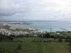
Buckner Bay, Okinawa
| Nakagusuku Bay 中城湾 Nakagusuku-wan |
|
|---|---|
| Buckner Bay | |

Nakagusuku Bay
|
|
| Location | Pacific Ocean |
| Coordinates | 26°15′18″N 127°49′55″E / 26.25500°N 127.83194°E |
| Type | Bay |
| Max. length | 20 km (12 mi) |
| Max. width | 14 km (8.7 mi) |
| Surface area | 220 km2 (85 sq mi) |
| Average depth | 15 m (49 ft) |
| Islands | Kudaka Island, Tsuken Island |
| Settlements | Uruma, Kitanakagusuku, Nakagusuku, Nishihara, Yonabaru, Nanjō |
Nakagusuku Bay (中城湾 Nakagusuku-wan?) is a bay on the southern coast of Okinawa Island on the Pacific Ocean in Japan. The bay covers 220 square kilometres (85 sq mi) and ranges between 10 metres (33 ft) to 15 metres (49 ft) deep. The bay is surrounded by the municipalities of Uruma, Kitanakagusuku, Nakagusuku, Nishihara, Yonabaru, Nanjō, all in Okinawa Prefecture. In 1852, while visiting the Ryukyu Kingdom, Commodore Matthew Perry mapped Okinawa and labeled Nakagusuku Bay as "Perry's Bay". During the final months of World War II, the bay became a U.S. Navy forward base, and was nicknamed "Buckner Bay".
In June 1945, American forces secured Okinawa. Nakagusuku Bay became an important U.S. anchorage. U. S. Army troops referred to it as "Buckner Bay", in memory of Lieutenant General Simon Bolivar Buckner, Jr., commander of U.S. land forces in the campaign, who was killed on 18 June.
Naval Base Buckner Bay was set up in the bay. It consisted of the anchorage, repair and depot ships, and various onshore facilities. The Base provided support to USN ships operating off Japan, and was also used to land supplies for forces on Okinawa. It was attacked several times during the remaining weeks of the war; USS Pennsylvania was torpedoed there by a Japanese aircraft. The base continued operations into the immediate postwar period.
...
Wikipedia
