Bužim
|
Bužim Бужим |
|
|---|---|
| Municipality and town | |
 |
|
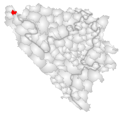
 Location of Bužim within Bosnia and Herzegovina. |
|
| Location in Bosnia and Herzegovina | |
| Coordinates: 45°03′N 16°02′E / 45.050°N 16.033°E | |
| Country |
|
| Entity | Federation of Bosnia and Herzegovina |
| Government | |
| • Municipality president | Zikrija Duraković (Independent) |
| Area | |
| • Total | 129 km2 (50 sq mi) |
| Population (2013 census) | |
| • Total | 20,298 |
| • Density | 157.3/km2 (407/sq mi) |
| Time zone | CET (UTC+1) |
| • Summer (DST) | CEST (UTC+2) |
| Area code(s) | +387 37 |
| Website | http://www.opcinabuzim.ba |
Bužim is a municipality situated in the most northwestern Bosnia and Herzegovina. Administratively, it is part of the Una-Sana Canton.
Bužim borders Bosanska Krupa to the east, Cazin to the south, Velika Kladuša to the west and north, and finally with the Republic of Croatia to the northeast. Geographically most of the municipality is mountainous. The total land area of Bužim is about 129 km2 (50 sq mi) with a population of 20,000. Bužim is about 180–400 meters above sea-level.
Bužim is situated in the North-West of B&H, actually in North-West part of Unsko-Sanski canton and it is one of eight municipalities in that canton. It borders on the municipalities of Bosanska Krupa (from East), Cazin (from the Soath), Velika Kladuša (from the West and North) and on the municipality Dvor on the river Una (Republic Croatia from the North-West). Territory of Bužim is mountainous. Cava and Dobro Selo spread in the East. Regional roads Bužim - Bosanska Otoka - Bosanska Krupa, i.e. Bosanska Otoka - Bosanski Novi connect Bužim with Bihać, i.e. Banja Luka. Route to South leads across Konjodor towards Cazin and further towards Bihać, and route to Dvor na Uni leads across Zaradostov and Buzevac. Route to the West leads through Lubarde - Pasin Brod - Todorovo all the way to Velika Kladuša (in the West). Route Bužim - Varoška Rijeka - Radica Most - Vrnograc – Velika Kladuša leads to Zagreb, i.e. route Radica Most – Bosanska Bojna – Glina – Zagreb.
Municipality of Bužim spreads over 130 km² and it has a population of 18.251. Population density is 150 inhabitants per km², which puts it in the very top of B&H by this criterion (According to the census population density in B&H in 1991 was 80,5 inhabitants per km²).
Actual territory of this municipality consists of 14 Local Communities: Bužim – administrative, economic, cultural, education and urban center has Secondary school "Hasan Musić" and primary school "12. September", Konjodor – primary school " Suljo Mirvić", Čava – primary school "Mirsad Salkić Džaja", Varoška Rijeka – primary school "Lotos i ljiljan" (lotus and lily), Local Communities Vrhovska, Lubarda, Elkasova Rijeka, Zaradostovo, Buzevci, Mrazovac, Rados and Brigovi have four-class primary schools. Local communities Bag and Jusufovići have no primary schools. Settlements are situated on 180 – 400 m above sea level. Radoš/630 meters, Corkovaca/603 meters, Konjodor/476 meters, Lubarda /420 meters, Cajino brdo/352 meters are remarkable for their height above sea level.
...
Wikipedia

