Bruntál
| Bruntál | |||
| Town | |||
|
|||
| Country | Czech Republic | ||
|---|---|---|---|
| Region | Moravian-Silesian | ||
| District | Bruntál | ||
| Commune | Bruntál | ||
| Elevation | 409 m (1,342 ft) | ||
| Coordinates | 49°59′N 17°27′E / 49.983°N 17.450°ECoordinates: 49°59′N 17°27′E / 49.983°N 17.450°E | ||
| Area | 29.34 km2 (11.33 sq mi) | ||
| Population | 16,784 (2014-12-31) | ||
| Density | 572/km2 (1,481/sq mi) | ||
| Founded | 1213 | ||
| Mayor | Petr Rys (STAN) | ||
| Timezone | CET (UTC+1) | ||
| - summer (DST) | CEST (UTC+2) | ||
| Postal code | 792 01 | ||
| Code | 79201 | ||
| Statistics: statnisprava.cz | |||
|
Website: www |
|||
Bruntál (Czech pronunciation: [ˈbruntaːl]; German: Freudenthal in Schlesien, Polish: Bruntal, Latin: Vallis Gaudiorum, Vrudental) is a town located near the western boundary of the Moravian-Silesian Region, in Czech Silesia. From 1938 to 1945 it was one of the municipalities in Sudetenland. A suitable position in the middle of the Jeseníky Mountains provides ample tourism opportunities to the town, which offers sites of cultural interest that include a Baroque castle and many historical buildings.
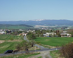
Bruntál is situated between the Hrubý Jeseník mountains and the rolling hills of the Nízký Jeseník mountains. The town lies in a valley surrounded by several hills (Uhlířský vrch, 672 m (2,205 ft); Vodárenský vrch, 599 m (1,965 ft); Zadní Zelený vrch, 563 m (1,847 ft); Kozinec, 639 m (2,096 ft)). The Black Creek (Černý potok) with its tributaries, the Oak Creek (Bukový potok), the Mare Creek (Kobylí potok), and the Waterworks Creek (Vodárenský potok), run through Bruntál. The Mare Pond (Kobylí rybník) is located in the middle of the town. The Oak Pond (Bukový rybník), with a surface area of 5 ha, lies almost 1 km (0.6 mi) northwest of the town. A dam reservoir, the Slezská Harta, 870 ha of sheet in size, is located approximately 5 km (3 mi) southeast of the town. There are many signs of ancient volcanic activity from the Quaternary period. Uhlířský vrch (672 m (2,205 ft)), Venušina sopka (655 m (2,149 ft)), Velký Roudný (780 m (2,560 ft)), Malý Roudný (770 m (2,530 ft)) are among these extinct volcanos. These volcanoes are a part of the Slunečná Highlands (Slunečná vrchovina) which is 16 km (10 mi) long lying southwards from Bruntál to Moravský Beroun, and includes the highest peak of the Nízký Jeseník mountains, Mount Slunečná (800 m (2,600 ft)).
Bruntál belongs to the Czech Massif which is the salient geological feature in the Czech Republic. Bruntál lies in the Moravian-Silesian Unit, which is a preplatform unit formed at the end of the Variscan orogeny (Hercynian orogeny). Bruntál is a part of the region that consists mainly of sedimentary rocks formed during the Mississippian Epoch of the Carboniferous period. In terms of Czech geology, this geologic period is called kulm. The mentioned region stretches from Brno to Krnov.
...
Wikipedia


