Brownville, Nebraska
| Brownville, Nebraska | |
|---|---|
| Village | |

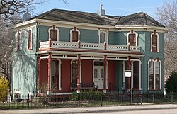
Carson House on Main Street, in Brownville Historic District
|
|
 Location of Brownville, Nebraska |
|
| Coordinates: 40°23′49″N 95°39′34″W / 40.39694°N 95.65944°WCoordinates: 40°23′49″N 95°39′34″W / 40.39694°N 95.65944°W | |
| Country | United States |
| State | Nebraska |
| County | Nemaha |
| Area | |
| • Total | 0.65 sq mi (1.68 km2) |
| • Land | 0.65 sq mi (1.68 km2) |
| • Water | 0 sq mi (0 km2) |
| Elevation | 958 ft (292 m) |
| Population (2010) | |
| • Total | 132 |
| • Estimate (2012) | 131 |
| • Density | 203.1/sq mi (78.4/km2) |
| Time zone | Central (CST) (UTC-6) |
| • Summer (DST) | CDT (UTC-5) |
| ZIP code | 68321 |
| Area code(s) | 402 |
| FIPS code | 31-06750 |
| GNIS feature ID | 0827698 |
Brownville is a village in Nemaha County, Nebraska, United States. The population was 132 at the 2010 census.
Established in 1854 and incorporated in 1856, Brownville was the largest town in the Nebraska Territory, with a population of 1,309 by 1880. Bordering slave-holding Missouri, the town became an important port on the Missouri River. Daniel Freeman, the first homesteader to file a claim under the Homestead Act of 1862, staked his claim at a New Year's Eve party in Brownville.
The rise of the railroad was ultimately Brownville's undoing. The railroads siphoned traffic away from the Missouri River's steamboats. Brownville's attempt to secure a railroad of its own was severely botched and led to immense tax increases to pay the bonds for the failed venture. This drove most of the population away and led to the county seat being transferred to Auburn in 1885. In 1856 Thomas Weston Tipton moved to the town to serve as a minister. He later became a longtime U.S. Senator, and ran an unsuccessful campaign for Governor of Nebraska. Omaha land magnates Herman and Augustus Kountze held large holdings in the early town.
...
Wikipedia
