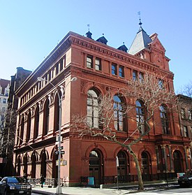
Brooklyn Heights Historic District
|
Brooklyn Heights Historic District
|
|

The Brooklyn Historical Society (2013)
|
|
| Location | Bounded by Atlantic Ave., Court and Fulton Sts. and the BQE Brooklyn, New York City |
|---|---|
| Coordinates | 40°41′48″N 73°59′48″W / 40.69667°N 73.99667°WCoordinates: 40°41′48″N 73°59′48″W / 40.69667°N 73.99667°W |
| Area | 140 acres (57 ha) |
| Architect | multiple |
| Architectural style | Greek Revival, Late Victorian, Gothic |
| NRHP Reference # | 66000524 |
| Significant dates | |
| Added to NRHP | October 15, 1966 |
| Designated NHLD | January 12, 1965 |
| Designated NYCL | September 26, 1978 |
The Brooklyn Heights Historic District is a historic district that comprises much of the Brooklyn Heights neighborhood of Brooklyn, New York City. It was named a National Historic Landmark in January, 1965, designated a New York City Landmark in November, 1965, and added to the National Register of Historic Places in October, 1966.
The district is bounded by Cadman Plaza West (Old Fulton Street) on the north, the Brooklyn-Queens Expressway on the west, Atlantic Avenue on the south, and an irregular line that partly follows Clinton and Henry Streets on the east.
Grace Episcopal Church, designed by Richard Upjohn, which held its first service in 1848, is in the district, as are Plymouth Church of the Pilgrims, Our Lady of Lebanon Maronite Catholic Cathedral, the First Presbyterian Church, the First Unitarian Congregational Society, the Long Island (Brooklyn) Historical Society, the Heights Casino and Casino Apartments, Packer Collegiate Institute, and St. Ann's and the Holy Trinity Church, among other historically notable buildings.
Middagh Street
150–159 Willow Street, early 19th-century Federal houses
Rowhouses on Remsen Street
...
Wikipedia


