Brooklyn Bridge–City Hall
|
Brooklyn Bridge–City Hall/Chambers Street
|
|||||||||||
|---|---|---|---|---|---|---|---|---|---|---|---|
| New York City Subway rapid transit station complex | |||||||||||

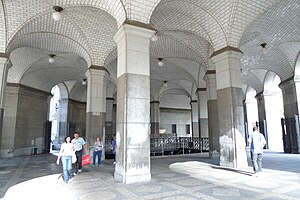
Municipal Building entrance
|
|||||||||||
| Station statistics | |||||||||||
| Borough | Manhattan | ||||||||||
| Locale | Civic Center | ||||||||||
| Coordinates | 40°42′46″N 74°0′17″W / 40.71278°N 74.00472°WCoordinates: 40°42′46″N 74°0′17″W / 40.71278°N 74.00472°W | ||||||||||
| Division | A (IRT), B (BMT) | ||||||||||
| Line |
IRT Lexington Avenue Line BMT Nassau Street Line |
||||||||||
| Services |
4 5 6 J Z |
||||||||||
| Transit connections |
|
||||||||||
| Structure | Underground | ||||||||||
| Other information | |||||||||||
| Opened | 1914 | ||||||||||
| Wireless service | |||||||||||
| Traffic | |||||||||||
| Passengers (2015) | 10,481,576 (station complex) |
||||||||||
| Rank | 29 out of 422 | ||||||||||
|
|||||||||||
|
|||||||||||
|
Chambers Street
|
|||||||||||
|---|---|---|---|---|---|---|---|---|---|---|---|
| New York City Subway rapid transit station | |||||||||||

Northbound platform. On the right is the unused middle platform and downtown platform.
|
|||||||||||
| Station statistics | |||||||||||
| Division | B (BMT) | ||||||||||
| Line | BMT Nassau Street Line | ||||||||||
| Services |
J Z |
||||||||||
| Structure | Underground | ||||||||||
| Platforms | 3 island platforms (2 active), 2 side platforms (1 demolished; 1 disused) | ||||||||||
| Tracks | 4 | ||||||||||
| Other information | |||||||||||
| Opened | August 4, 1913 | ||||||||||
| Accessible |
|
||||||||||
| Wireless service | |||||||||||
| Station succession | |||||||||||
|
|||||||||||
|
|||||||||||
|
|
|||||||||||
|
Chambers Street Subway Station (Dual System BMT)
|
|||||||||||
| MPS | New York City Subway System MPS | ||||||||||
| NRHP Reference # | 05000669 | ||||||||||
| Added to NRHP | July 6, 2005 | ||||||||||
|
Brooklyn Bridge–City Hall
|
|
|---|---|
| New York City Subway rapid transit station | |

Uptown island platform
|
|
| Station statistics | |
| Address | Park Row & Centre Street New York, NY 10007 |
| Division | A (IRT) |
| Line | IRT Lexington Avenue Line |
| Services |
4 5 6 |
| Structure | Underground |
| Platforms | 2 island platforms (in service) cross-platform interchange 2 side platforms (abandoned) |
| Tracks | 4 |
| Other information | |
| Opened | October 27, 1904 |
| Accessible |
|
| Wireless service | |
| Former/other names | Brooklyn Bridge Brooklyn Bridge–Worth Street Chambers Street |
| Station succession | |
| Next north |
14th Street–Union Square (express): 4 Canal Street (local): 4 Worth Street (local; closed): no regular service |
| Next south | (Terminal): 6 City Hall (local; closed): no regular service Fulton Street: 4 |
|
|
|
| Next |
Wikipedia
...
|


