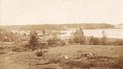
Brooklin, Maine
| Brooklin, Maine | |
|---|---|
| Town | |

Center Harbor in 1909
|
|
| Location within the state of Maine | |
| Coordinates: 44°16′31″N 68°33′34″W / 44.27528°N 68.55944°W | |
| Country | United States |
| State | Maine |
| County | Hancock |
| Incorporated | 1849 |
| Area | |
| • Total | 41.18 sq mi (106.66 km2) |
| • Land | 17.92 sq mi (46.41 km2) |
| • Water | 23.26 sq mi (60.24 km2) |
| Elevation | 33 ft (10 m) |
| Population (2010) | |
| • Total | 824 |
| • Estimate (2012) | 820 |
| • Density | 46.0/sq mi (17.8/km2) |
| Time zone | Eastern (EST) (UTC-5) |
| • Summer (DST) | EDT (UTC-4) |
| ZIP code | 04616 |
| Area code(s) | 207 |
| FIPS code | 23-07800 |
| GNIS feature ID | 0582370 |
Brooklin is a town in Hancock County, Maine, United States. The population was 824 at the 2010 census. It is home to WoodenBoat Magazine, Brooklin Boat Yard, and numerous boatbuilders, artists, writers, musicians, and potters.
Brooklin was originally part of a larger town, then Sedgwick broke off and formed its own town. A few weeks later, the name was changed to Brooklin, after the brook line which separated it from Sedgwick. Using porgy oil as a fertilizer, the difficult soil was made productive, and hay became the principal crop. With excellent harbors, however, the main occupations were fishing and seafaring. By 1859, when the population was 1,002, it also had five boot and shoemaking factories, as well as two barrel manufacturers. By 1886, the town was noted for producing smoked herring in considerable quantities. Canning lobster had also become an important business.
Street view in 1909
Old High School c. 1915
Redman Cottage in 1909
According to the United States Census Bureau, the town has a total area of 41.18 square miles (106.66 km2), of which 17.92 square miles (46.41 km2) is land and 23.26 square miles (60.24 km2) is water. Brooklin is situated on the Benjamin River overlooking Jericho Bay.
The town is crossed by Maine State Route 175.
As of the census of 2010, there were 824 people, 397 households, and 238 families residing in the town. The population density was 46.0 inhabitants per square mile (17.8/km2). There were 874 housing units at an average density of 48.8 per square mile (18.8/km2). The racial makeup of the town was 97.9% White, 1.0% Asian, 0.4% from other races, and 0.7% from two or more races. Hispanic or Latino of any race were 0.5% of the population.
...
Wikipedia

