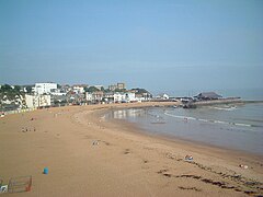
Broadstairs
| Broadstairs | |
|---|---|
 Viking Bay, Broadstairs |
|
| Broadstairs shown within Kent | |
| Population | 24,903 (Broadstairs and St Peter's parish 2011) |
| OS grid reference | TR395675 |
| • London | 81.6 miles (131.3 km) |
| Civil parish | |
| District | |
| Shire county | |
| Region | |
| Country | England |
| Sovereign state | United Kingdom |
| Post town | Broadstairs |
| Postcode district | CT10 |
| Dialling code | 01843 |
| Police | Kent |
| Fire | Kent |
| Ambulance | South East Coast |
| EU Parliament | South East England |
| UK Parliament | |
Broadstairs is a coastal town on the Isle of Thanet in the Thanet district of east Kent, England, about 80 miles (130 km) east of London. It is part of the civil parish of Broadstairs and St Peter's, which includes St Peter's and had a population in 2011 of about 25,000. Situated between Margate and Ramsgate, Broadstairs is one of Thanet's seaside resorts, known as the "Jewel in Thanet's crown". The town's crest motto is Stella Maris ("Star of the Sea"). The name derives from a former flight of steps in the chalk cliff, which led from the sands up to the 11th-century shrine of St Mary on the cliff's summit.
The town spreads from Haine Road in the west to Kingsgate (named after the landing of King Charles II in 1683) a hamlet in St Peter parish in the north and to Dumpton in the south (named after the yeoman Dudeman who farmed there in the 13th century). The hamlet of Reading (formerly Reden or Redyng) Street was established by Flemish refugees in the 17th century.
The inland village of St Peter's was established after the building of a parish church in about 1080. The coastal confederation of Cinque Ports during its mediæval period consisted of a confederation of 42 towns and villages in all. This included St Peter's, as a 'limb' of Dover. On the nearby coast was a cliff-top shrine, the Shrine of Our Lady, at what was then called Bradstow(e), meaning "broad place" (perhaps referring to the wide bay).
...
Wikipedia

