Brixton Pound
| Brixton | |
|---|---|
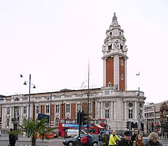
 Lambeth Town Hall |
|
| Brixton shown within Greater London | |
| Population | 78,536 (2011 census) |
| OS grid reference | TQ315755 |
| • Charing Cross | 3.8 mi (6.1 km) NNW |
| London borough | |
| Ceremonial county | Greater London |
| Region | |
| Country | England |
| Sovereign state | United Kingdom |
| Post town | LONDON |
| Postcode district | SE5 |
| Postcode district | SW2 |
| Postcode district | SW9 |
| Dialling code | 020 |
| Police | Metropolitan |
| Fire | London |
| Ambulance | London |
| EU Parliament | London |
| UK Parliament | |
| London Assembly | |
| Brixton pound | |
|---|---|
| Demographics | |
| User(s) | Brixton |
Brixton is a district of south London, England, within the London Borough of Lambeth. The area is identified in the London Plan as one of 35 major centres in Greater London.
Brixton is mainly residential with a prominent street market and substantial retail sector. It is a multiethnic community, with a large percentage of its population being of Caribbean descent. It lies within Inner south London and is bordered by , Clapham, Streatham, Camberwell, Tulse Hill and Herne Hill. The district houses the main offices of the London Borough of Lambeth.
Brixton is 2.7 miles (4.3 km) south-southwest of the geographical centre of London near Lambeth North tube station.
The name Brixton is thought to originate from Brixistane, meaning the stone of Brixi, a Saxon lord. Brixi is thought to have erected a boundary stone to mark the meeting place of the ancient hundred court of Surrey. The location is unknown but is thought to be at the top of Brixton Hill, at a road known at the time as Bristow or Brixton Causeway, long before any settlement in the area. Brixton marks the rise from the marshes of North Lambeth up to the hills of Upper Norwood and Streatham. At the time the River Effra flowed from its source in Upper Norwood through Herne Hill to Brixton. At Brixton the river was crossed by low bridges for Roman roads to the south coast of Britain, now Brixton Road and Clapham Road. The main roads were connected through a network of medieval country lanes, such as Acre Lane, Coldharbour Lane, Brixton Water Lane and Lyham Road, formerly Black Lane. It was only at the end of the 18th century that villages and settlements formed around Brixton, as the original woodland was gradually reduced until the area was covered in farmland and market gardens known for game and strawberries.
...
Wikipedia

