Bridgend
Bridgend
|
|
|---|---|
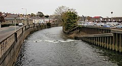
 The Ogmore River. To the left of the river is Quarella Road; to the right, a superstore and car park |
|
 The Old Bridge was built in 1425, repaired in 1775 and restored in 2005 |
|
| Bridgend shown within Bridgend | |
| Population | 49,404 (April 2011) |
| OS grid reference | SS905805 |
| Community | |
| Principal area | |
| Ceremonial county | |
| Country | Wales |
| Sovereign state | United Kingdom |
| Post town | BRIDGEND |
| Postcode district | CF31-33, CF35 |
| Dialling code | 01656 |
| Police | South Wales |
| Fire | South Wales |
| Ambulance | Welsh |
| EU Parliament | Wales |
| UK Parliament | |
| Welsh Assembly | |
Bridgend (English pronunciation: /brᵻˈdʒɛnd/; Welsh: Pen-y-bont ar Ogwr, meaning "the end (or head) of the bridge on the Ogmore") is a town in Bridgend County Borough in Wales, 18 miles (29 km) west of the capital Cardiff and 20 miles (32 km) east of Swansea. The river crossed by the original bridge, which gave the town its name, is the River Ogmore, but the River Ewenny also passes to the south of the town.
Historically a part of Glamorgan, Bridgend has greatly expanded in size since the early 1980s – the 2001 census recorded a population of 39,429 for the town and the 2011 census reported that the Bridgend Local Authority had a population of 139,200 — up from 128,700 in 2001. This 8.2% increase was the largest increase in Wales except for Cardiff. The town is undergoing a redevelopment project, with the town centre mainly pedestrianised and ongoing works including Brackla Street Centre redevelopment to Bridgend Shopping Centre, Rhiw Car Park redevelopment, ongoing public realm improvements and the upgrade of the Bridgend Life Centre and demolition of Sunnyside offices to accommodate a large retirement complex.
Several prehistoric burial mounds have been found in the vicinity of Bridgend, suggesting that the area was settled before Roman times. The A48 between Bridgend and Cowbridge has a portion, known locally as "Crack Hill", a Roman road and the 'Golden Mile' where it is believed Roman soldiers were lined up to be paid. The Vale of Glamorgan would have been a natural low-level route west to the Roman fort and harbour at Neath (Nidum) from settlements in the east like Cardiff and Caerleon (Isca).
...
Wikipedia

