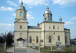
Briceni
| Briceni | |||
|---|---|---|---|
 |
|||
|
|||
| Location within Moldova | |||
| Coordinates: 48°22′N 27°06′E / 48.367°N 27.100°ECoordinates: 48°22′N 27°06′E / 48.367°N 27.100°E | |||
| Country |
|
||
| district | Briceni District | ||
| Area | |||
| • Total | 10 km2 (4 sq mi) | ||
| Elevation | 39 m (128 ft) | ||
| Population (2012) | |||
| • Total | 9,900 | ||
| • Density | 990/km2 (2,600/sq mi) | ||
| Time zone | EET (UTC+2) | ||
| • Summer (DST) | EEST (UTC+3) | ||
| Climate | Dfb | ||
Briceni (Romanian pronunciation: [briˈt͡ʃenʲ]; Moldovan Cyrillic: Бричень; Yiddish: Brichon, Russian: Brichany [Бричаны]) is a city in northern Moldova. It is the seat of Briceni District.
At the 2004 census, the city had a population of 8,765. At the 1930 census, there were two localities: Briceni Târg (literally Briceni Fair), and Briceni Sat (literally Briceni village), and at the time they were part of Plasa Briceni of Hotin County.
The town has been also called: Berchan, Bricheni, Bricheni Târg, Bricheni Sat, Britchan, Britchani, Britsiteni.
A village, approximately 50 kilometres (30 mi) to the east to the city, is also known as Briceni. It is at 48° 22´ north latitude and 27° 42´ east longitude, which puts that town 174 km (108 mi) north northwest of Chişinău.
The Jewish cemetery of Briceni, containing some 2,500 tombstones, is heavily overgrown, but generally preserved. It is located in the eastern vicinities of the town, left of the road R11 leading to Ocnița.
Briceni is twinned with:
...
Wikipedia


