Briarcliff Manor
| Briarcliff Manor, New York | |||
| Village | |||
|
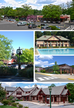
Clockwise from top: the Village Center; village pool at Law Memorial Park; Briarcliff High School; Briarcliff Manor Public Library; village clock and Municipal Building.
|
|||
|
|||
| Official name: Village of Briarcliff Manor | |||
| Named for: The Irish family home "Brier Cliff" | |||
| Motto: A Village between Two Rivers | |||
| Nickname: Briarcliff | |||
| Country | United States | ||
|---|---|---|---|
| State | New York | ||
| Region | Hudson Valley | ||
| County | Westchester | ||
| Municipality | Mount Pleasant and Ossining | ||
| Parts | Chilmark and Scarborough | ||
| Landmark | Briarcliff Manor Public Library | ||
| River | Hudson | ||
| Elevation | 351 ft (107 m) | ||
| Coordinates | 41°09′N 073°51′W / 41.150°N 73.850°WCoordinates: 41°09′N 073°51′W / 41.150°N 73.850°W | ||
| Highest point | 1,200 ft SW of NGS station mark LX4016, off Farm Road | ||
| - elevation | 533 ft (162 m) | ||
| - coordinates | 41°09′24″N 73°50′46″W / 41.15667°N 73.84611°W | ||
| Lowest point | Sea level (at the Hudson River) | ||
| - elevation | 0 ft (0 m) | ||
| Area | 6.7 sq mi (17 km2) | ||
| - land | 5.9 sq mi (15 km2) | ||
| - water | 0.8 sq mi (2 km2) | ||
| Population | 7,867 (2010) | ||
| Density | 1,200/sq mi (463/km2) | ||
| Settled | 1890s | ||
| Incorporation | 1902 | ||
| Government | Briarcliff Manor Village Hall | ||
| - location | 1111 Pleasantville Road | ||
| - coordinates | 41°08′56″N 73°49′43″W / 41.14889°N 73.82861°W | ||
| Mayor | Lori A. Sullivan (People's Caucus) | ||
| Board |
Trustees
|
||
| Timezone | North American Eastern (EST) (UTC-5) | ||
| - summer (DST) | EDT (UTC-4) | ||
| ZIP code | 10510 | ||
| Area code | 914 | ||
| FIPS code | 36-08103 | ||
| GNIS feature ID | 969912, 2391558 | ||
| VIAF code | VIAF: 130216697 | ||
|
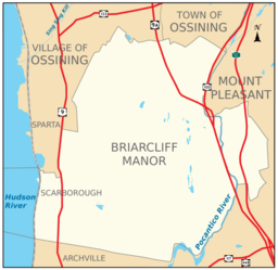
Boundaries of and major thoroughfares through Briarcliff Manor.
|
|||
|
Location of Briarcliff Manor within Westchester County and the county within New York.
|
|||
|
Website: www |
|||
Briarcliff Manor /ˈbraɪərklɪf/ is a suburban village in Westchester County, New York, around 30 miles (50 km) north of New York City. It is on 5.9 square miles (15 km2) of land on the east bank of the Hudson River, geographically shared by the towns of Mount Pleasant and Ossining. Briarcliff Manor includes the communities of Scarborough and Chilmark, and is served by the Scarborough station of the Metro-North Railroad's Hudson Line. A section of the village, including buildings and homes covering 376 acres (152 ha), is part of the Scarborough Historic District and was listed on the National Register of Historic Places in 1984. The village motto is "A Village between Two Rivers", reflecting Briarcliff Manor's location between the Hudson and Pocantico Rivers. Although the Pocantico is the primary boundary between Mount Pleasant and Ossining, since its incorporation the village has spread into Mount Pleasant.
In the precolonial era, the village's area was inhabited by a band of the Wappinger tribes of Native Americans. In the early 19th century, the area was known as Whitson's Corners. Walter William Law moved to the area and purchased lands during the 1890s. Law developed the village, establishing schools, churches, parks, and the Briarcliff Lodge. Briarcliff Manor was incorporated as a village in 1902, and celebrated its centennial on November 21, 2002. The village has grown from 331 people when established to 7,867 in the 2010 census.
...
Wikipedia


