Brentwood, Pennsylvania
| Brentwood | |
| Borough | |
|
4th of July Celebration at Brentwood Towne Square
|
|
| Official name: Borough of Brentwood | |
| Country | United States |
|---|---|
| State | Pennsylvania |
| County | Allegheny |
| Elevation | 1,225 ft (373 m) |
| Coordinates | 40°22′28″N 79°58′34″W / 40.37444°N 79.97611°WCoordinates: 40°22′28″N 79°58′34″W / 40.37444°N 79.97611°W |
| Area | 1.5 sq mi (3.9 km2) |
| - land | 1.5 sq mi (3.9 km2) |
| - water | 0.0 sq mi (0.0 km2), 0% |
| Population | 9,643 (2010) |
| Density | 6,428.7/sq mi (2,482.1/km2) |
| Incorporated | May 15, 1916 |
| Mayor | Dennis Troy |
| Timezone | EST (UTC-5) |
| - summer (DST) | EDT (UTC-4) |
| ZIP code | 15227 |
| Area code | 412 |
| School District | Brentwood |
|
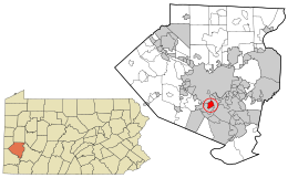
Location in Allegheny County and the state of Pennsylvania
|
|
| Website: http://www.brentwoodborough.com | |
Brentwood is a borough in Allegheny County, Pennsylvania, United States, and is part of the Pittsburgh Metro Area. The population was 9,643 at the 2010 census.
Brentwood is located at 40°22′28″N 79°58′34″W / 40.37444°N 79.97611°W (40.374469, -79.976179). According to the United States Census Bureau, the borough has a total area of 1.5 square miles (3.9 km2), all of it land.
The borough is located in the Allegheny Plateau region of the United States, and is situated 5 miles (8 km) south of the confluence of the Allegheny River and the Monongahela River to form the Ohio River.
Due to its position between the Great Lakes and the windward side of the Allegheny Mountains, Brentwood, along with the rest of the region, receives plentiful precipitation which supports lush vegetation. Also, because it is on the windward side of the mountains, it is often cloudy, having 203 cloudy days per year. The winter is particularly cloudy, with only 28 percent sunshine in December and 23 cloudy days. In the winter, when a northwest flow establishes itself over the Great Lakes, the wind blows from Lake Erie across eastern Ohio and western Pennsylvania. That wind carries moist air from the lake, producing clouds and heavy snow squalls.
...
Wikipedia


