Bregenz Forest
| Bregenz Forest | |
|---|---|
| Bregenzerwald | |

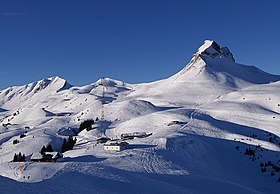
Damülser Mittagspitze, 2,095m
|
|
| Highest point | |
| Peak | Glatthorn |
| Elevation | 2,134 m (7,001 ft) |
| Coordinates | 47°15′56″N 9°52′48″E / 47.26556°N 9.88000°ECoordinates: 47°15′56″N 9°52′48″E / 47.26556°N 9.88000°E |
| Geography | |
| Country | Austria |
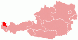
| States | Vorarlberg |
| Parent range | Northern Limestone Alps |
The Bregenz Forest (German: Bregenzerwald) is one of the main regions in the state of Vorarlberg, Austria. It overlaps, but is not conterminous with, the Bregenz Forest Mountains which are a range of the Northern Limestone Alps, specifically the northern flysch zone. It is the drainage basin of the Bregenzer Ach river.
The inhabitants often divide the Bregenz Forest into two main areas, the Vorderwald ("lower forest") and Hinterwald ("upper forest"). The Vorderwald, with its hills and low mountains, is closest to the Rhine valley. The Hinterwald has the higher mountains, with altitudes of up to 2,000 metres. Each of the two regions has its own distinctive dialect variations.
The principal villages in the Bregenz Forest are Bezau (the local capital), Alberschwende, and Egg. Alberschwende as a historic "Hofsteig" municipality did not used to be part of the Bregenz Forest region.
Lower Bregenz Forest (Vorderer Bregenzerwald) (red)
Upper Bregenz Forest (Hinterer Bregenzerwald) (blue)
The population of the Bregenz Forest earns a living from tourism, agriculture and trade that is strongly connected with the wood processing industry. Many locals also commute to work in the Rhine Valley, Vorarlberg's economic centre. The "Werkraum Bregenzerwald" is a coalition of trade and industry in the region, which also holds the design competition "Handwerk+Form" ("craft + shape") every three years.
In spring 2011, the three-level agricultural structure of the Bregenz Forest, also known as Alpine transhumance, was included in the Austrian list of cultural landscape candidates for recognition by UNESCO. The proposal recognises that the Bregenz Forest is "an impressive landscape on the north side of the Alps" that has "largely maintained its traditional farming structure". These include linear or nucleated villages, characteristic of the region, with farmsteads dating back to the 18th and 19th centuries. In addition, there are many small craft workshops amongst the farming community. Singled out for particular mention are the villages of Thal, Schwarzenberg and Schoppernau, with their fine examples of original Bregenz Forest houses ("Wälderhäuser").
...
Wikipedia

