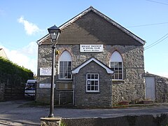
Breage, Cornwall
Breage
|
|
|---|---|
 A former Methodist chapel |
|
| Breage shown within Cornwall | |
| Population | 3,000 (Civil Ward, 2011) |
| OS grid reference | SW615285 |
| Unitary authority | |
| Ceremonial county | |
| Region | |
| Country | England |
| Sovereign state | United Kingdom |
| Post town | HELSTON |
| Postcode district | TR13 |
| Dialling code | 01736 |
| Police | Devon and Cornwall |
| Fire | Cornwall |
| Ambulance | South Western |
| EU Parliament | South West England |
| UK Parliament | |
Breage (/ˈbriːɡ/ BREEG, local /ˈbreɪɡ/ BRAYG;Cornish: Eglosbrek) is a civil parish and village in Cornwall, England, United Kingdom. The village is three miles (5 km) west of Helston.
Other settlements in the parish include the villages of Ashton, Carleen and Godolphin Cross; the coastal village of Praa Sands; and the Great Work mine. The ward population at the Census 2011 had increased to 4,757. Breage civil parish had a population increase to 3181.
Breage is named after Saint Breaca, a missionary from Ireland (to whom the 15th-century church is dedicated) and it is in the former Kerrier District.
The parish was at the time of Domesday Book within the manor of Binnerton. There were 8 hides of land with enough for 60 ploughs. There were 32 villagers and 25 smallholders with 15 ploughs between them. Apart from the arable land there was 2 acres (0.81 ha) of meadow, 2 sq leagues of pasture and half a sq league of woodland. Livestock were 45 mares, 13 cattle, 5 pigs and 60 sheep; the annual value was £10.
...
Wikipedia

