Kerrier
| Kerrier District | |
|---|---|
 |
|
| Population | |
| • 1973 | 78,080 |
| • 2001 | 92,536 |
| History | |
| • Origin |
|
| • Created | 1 April 1974 |
| • Abolished | 1 April 2009 |
| • Succeeded by | Cornwall unitary authority |
| Status | District |
| ONS code | 15UD |
| Government | District council |
| • HQ | Camborne |
 |
|
| Subdivisions | |
| • Type | Civil parishes |
 |
|
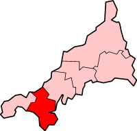
Kerrier (Cornish: Keryer) was a local government district in Cornwall, England, United Kingdom. It was the most southerly district in the United Kingdom, other than the Isles of Scilly. Its council was based in Camborne 50°12′50″N 5°17′49″W / 50.214°N 5.297°WCoordinates: 50°12′50″N 5°17′49″W / 50.214°N 5.297°W.
Other towns in the district included Redruth and Helston. The district also contained the Lizard Peninsula.
Kerrier is named after one of the ancient administrative Hundreds of Cornwall, Kerrier, which covered broadly the same area, but did not have a coast on the north.
The district was formed on 1 April 1974, as a merger of the borough of Helston, the urban district of Camborne-Redruth and Kerrier Rural District.
...
Wikipedia
