Braer Storm of January 1993

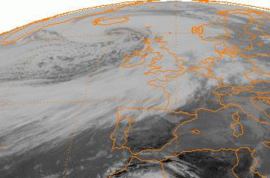
METEOSAT satellite image of the Braer Storm near peak intensity on January 10, 1993
|
|
| Type | |
|---|---|
| Formed | 8 January 1993 |
| Dissipated | 17 January 1993 |
| Lowest pressure | 914 millibars (hPa; 27.0 inHg) |
| Areas affected | North Atlantic, Greenland, Iceland, Western Europe |
The Braer Storm of January 1993 was the most intense extratropical cyclone on record for the northern Atlantic ocean. Developing as a weak frontal wave on 8 January 1993, the system moved rapidly northeast. The combination of the absorption of a second low-pressure area to its southeast, a stronger than normal sea surface temperature differential along its path, and the presence of a strong jet stream aloft led to a rapid strengthening of the storm, with its central pressure falling to an estimated 914 hPa (914 mb; 27.0 inHg) on 10 January. Its strength was well predicted by forecasters in the United Kingdom, and warnings were issued before the low initially developed.
Gale-force winds covered the far northern Atlantic between Western Europe and Atlantic Canada, due to the intensity of this storm, with hurricane-force winds confined near its center of circulation. After reaching its peak intensity, the system weakened as it moved into the far northeast Atlantic, dissipating by 17 January. This storm caused blizzards across much of Scotland and led to the final breakup of the oil tanker MV Braer, which had been stranded in rocks off the Shetland Islands by a previous storm nearly a week beforehand.
A weak frontal wave, a low-pressure system forming along a weather front with very strong temperature contrast, developed on the afternoon of 8 January to the southeast of Newfoundland with a central pressure of 1,008 hPa (29.8 inHg) The system moved at a quick pace to the east-northeast at around 110 km/h (68 mph), deepening slowly. As the storm tracked more northeasterly, development accelerated, and early on the morning of 9 January its central pressure had fallen to 988 hPa (29.2 inHg). A new low pressure area formed along the system's cold front to its south. By noon, the forward motion of the main cyclone accelerated to nearly 150 km/h (93 mph) and its central pressure began to bomb, then down to 974 hPa (28.8 inHg) as it passed through the far northern Atlantic. This strengthening was enhanced by a strong jet stream with measured winds of 440 km/h (270 mph), and a stronger than normal sea surface temperature gradient along its path from the Grand Banks of Newfoundland towards Iceland.
...
Wikipedia
