Bradner
| Bradner, Ohio | |
|---|---|
| Village | |

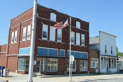
Crocker Street downtown
|
|
 Location of Bradner, Ohio |
|
 Location of Bradner in Wood County |
|
| Coordinates: 41°19′26″N 83°26′15″W / 41.32389°N 83.43750°WCoordinates: 41°19′26″N 83°26′15″W / 41.32389°N 83.43750°W | |
| Country | United States |
| State | Ohio |
| County | Wood |
| Township | Montgomery |
| Government | |
| • Mayor | Virgil J. Shull Jr. |
| Area | |
| • Total | 0.62 sq mi (1.61 km2) |
| • Land | 0.62 sq mi (1.61 km2) |
| • Water | 0 sq mi (0 km2) |
| Elevation | 696 ft (212 m) |
| Population (2010) | |
| • Total | 985 |
| • Estimate (2012) | 998 |
| • Density | 1,588.7/sq mi (613.4/km2) |
| Time zone | Eastern (EST) (UTC-5) |
| • Summer (DST) | EDT (UTC-4) |
| ZIP code | 43406 |
| Area code(s) | 419 |
| FIPS code | 39-08112 |
| GNIS feature ID | 1048541 |
| Website | www.bradnerohio.org |
Bradner is a village in Wood County, Ohio, United States. The population was 985 at the 2010 census.
Bradner was platted in 1875, and named for John Bradner, proprietor. A post office called Bradner has been in operation since 1876. The village was incorporated in 1889.
Bradner is located at 41°19′26″N 83°26′15″W / 41.32389°N 83.43750°W (41.324011, -83.437633).
According to the United States Census Bureau, the village has a total area of 0.62 square miles (1.61 km2), all land.
As of the census of 2010, there were 985 people, 388 households, and 265 families residing in the village. The population density was 1,588.7 inhabitants per square mile (613.4/km2). There were 445 housing units at an average density of 717.7 per square mile (277.1/km2). The racial makeup of the village was 97.2% White, 0.4% African American, 0.1% Native American, 0.3% Asian, 0.5% from other races, and 1.5% from two or more races. Hispanic or Latino of any race were 5.1% of the population.
...
Wikipedia
