Boyce, Virginia
| Boyce, Virginia | |
|---|---|
| Town | |

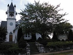
8 Old Chapel Road, Boyce; built in 1916
|
|
 Location of Boyce in Virginia |
|
| Coordinates: 39°5′35″N 78°3′33″W / 39.09306°N 78.05917°WCoordinates: 39°5′35″N 78°3′33″W / 39.09306°N 78.05917°W | |
| Country | |
| State |
|
| County |
|
| Area | |
| • Total | 0.36 sq mi (0.93 km2) |
| • Land | 0.36 sq mi (0.93 km2) |
| • Water | 0.0 sq mi (0.0 km2) |
| Elevation | 597 ft (182 m) |
| Population (2010) | |
| • Total | 589 |
| • Density | 1,643/sq mi (634.2/km2) |
| Time zone | Eastern (EST) (UTC-5) |
| • Summer (DST) | EDT (UTC-4) |
| ZIP code | 22620 |
| Area code(s) | 540 |
| FIPS code | 51-08984 |
| GNIS feature ID | 1492615 |
| Website | townofboyceva |
Boyce is a town in Clarke County, Virginia, United States. The population was 589 at the 2010 census, up from 426 at the 2000 census.
Boyce is located in western Clarke County at 39°5′35″N 78°3′33″W / 39.09306°N 78.05917°W (39.093118, -78.059190), along U.S. Route 340. It is 6 miles (10 km) southwest of Berryville, the county seat and 16 miles (26 km) northeast of Front Royal.
According to the United States Census Bureau, the town has a total area of 0.35 square miles (0.9 km2), all of it land.
The town is situated at the crossing of the Norfolk & Western Railway and the Winchester and Berry's Ferry Turnpike about 2 miles (3 km) northwest of Millwood, of which it is the shipping point; 3 miles (5 km) each from Old Chapel and White Post; and 9 miles (14 km) southeast of Winchester, Virginia. It is built upon a ridge, which drains on the east into Page Brook and to the west into Roseville Run. It is apparently well underlaid with water; the town well reaches to a recorded depth of 165 feet (50 m).
As of the census of 2000, there were 426 people, 159 households, and 114 families residing in the town. The population density was 1,179.9 people per square mile (456.9/km²). There were 168 housing units at an average density of 465.3 per square mile (180.2/km²). The racial makeup of the town was 86.38% White, 11.74% African American, 1.17% Native American, 0.23% Asian, and 0.47% from two or more races.
...
Wikipedia
