Bowerston, Ohio
| Bowerston, Ohio | |
|---|---|
| Village | |
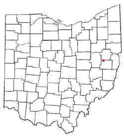
 Location of Bowerston, Ohio |
|
 Location of Bowerston in Harrison County |
|
| Coordinates: 40°25′37″N 81°11′15″W / 40.42694°N 81.18750°WCoordinates: 40°25′37″N 81°11′15″W / 40.42694°N 81.18750°W | |
| Country | United States |
| State | Ohio |
| County | Harrison |
| Area | |
| • Total | 0.51 sq mi (1.32 km2) |
| • Land | 0.51 sq mi (1.32 km2) |
| • Water | 0 sq mi (0 km2) |
| Elevation | 951 ft (290 m) |
| Population (2010) | |
| • Total | 398 |
| • Estimate (2012) | 397 |
| • Density | 780.4/sq mi (301.3/km2) |
| Time zone | Eastern (EST) (UTC-5) |
| • Summer (DST) | EDT (UTC-4) |
| ZIP code | 44695 |
| Area code(s) | 740 |
| FIPS code | 39-07916 |
| GNIS feature ID | 1048536 |
Bowerston is a village in Harrison County, Ohio, United States. The population was 398 at the 2010 census.
The village of Bowerston was settled in the early 19th century by Barnhard Bower and his brother John. When they first moved to the area, two mills were already built on the south side of Conotton Creek. One mill was a sawmill, the other a gristmill, and in 1804, the Bower brothers began to rebuild the mills. In 1816, the settlement called Bower's Mills was laid out and later it was called Bowersville and finally Bowerston. Bowerston was platted by David Bower, Henry Hoover, and Nathaniel Bower on August 21, 1851 and was filed in court August 2, 1852. The village was incorporated April 2, 1883.
Bowerston is located at 40°25′37″N 81°11′15″W / 40.42694°N 81.18750°W (40.426806, -81.187523).
According to the United States Census Bureau, the village has a total area of 0.51 square miles (1.32 km2), all land.
As of the census of 2010, there were 398 people, 156 households, and 92 families residing in the village. The population density was 780.4 inhabitants per square mile (301.3/km2). There were 179 housing units at an average density of 351.0 per square mile (135.5/km2). The racial makeup of the village was 98.7% White, 0.8% African American, 0.3% Native American, and 0.3% from two or more races.
...
Wikipedia
