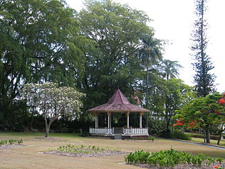
Bowen Park, Brisbane
| Bowen Park | |
|---|---|

Bandstand in Bowen Park
|
|
| Location | Brisbane, Queensland, Australia |
| Area | 17,740m² |
| Created | 1863 |
| Operated by | Brisbane City Council |
| Designation | State Heritage Place (Queensland Heritage Register) |
| Bowen Park, Brisbane | |
|---|---|
| Location | O'Connell Terrace, Bowen Hills, City of Brisbane, Queensland, Australia |
| Coordinates | 27°26′56″S 153°01′47″E / 27.4489°S 153.0298°ECoordinates: 27°26′56″S 153°01′47″E / 27.4489°S 153.0298°E |
| Design period | 1840s - 1860s (mid-19th century) |
| Built | 1863 - 1950s |
| Official name: Bowen Park | |
| Type | state heritage (built, landscape) |
| Designated | 26 February 1999 |
| Reference no. | 601523 |
| Significant period | 1914-1950s (fabric) 1863-1914 (historical) 1863-ongoing (social) |
| Significant components | garden edging/balustrades/planter boxes, garden - ornamental/flower, toilet block/earth closet/water closet, rotunda, gate - entrance, wall/s - retaining, steps/stairway, trees/plantings, pathway/walkway |
Bowen Park is a heritage-listed park of 17,740 m² at O'Connell Terrace (corner of Bowen Bridge Road), Bowen Hills, City of Brisbane, Queensland, Australia. It was built from 1863 to 1950s. It was also known as the Acclimatisation Society Gardens. It was added to the Queensland Heritage Register on 26 February 1999.
Bowen Park is a 1.774 hectare remnant of a parcel of land of almost forty acres (160,000m²) bordered by O'Connell Terrace, Bowen Bridge Road, Gregory Terrace and Brooke Street. The park is important for its survival and continued use since 1863 as a park for public pleasure in inner-city Brisbane, an area under pressure to accommodate increased urban development and consolidation. The Queensland Government granted land to the Queensland Acclimatisation Society (QAS) in two parcels in 1863 and 1866, this site was then well out of town on the edge of development and had been worked as a brickfield. Part of this land lay along the watercourse of York's Hollow and the remainder was remnant bushland and brickworks. The site was not ideal for establishing a garden, the soil being of poor quality and rocky in parts, and required substantial reclamation work to form the gardens.
The society named the Gardens after George Bowen, the Governor of Queensland and their patron. Over the years parts of the land were progressively leased, sold and resumed for other purposes, resulting in only 17,740m² (4.383 acres) remaining by 1955 in the north-western corner of the original site (on the corner of O'Connell Terrace and Bowen Bridge Road).
The Bowen Park of 1862 consisted of a series of clay holes and rough bush with a wretched bush track leading from the city across the Fortitude Valley.The area became an attractive and popular recreational venue from 1863 when the QAS established its gardens which extended from the creek to Bowen Bridge Road. The gardens were named Bowen Park, Acclimatisation Society Gardens in honour of the first governor of Queensland and initial patron of the QAS, Sir George Ferguson Bowen, who was active in the establishment of the QAS.
...
Wikipedia

