Boulder, Utah
| Boulder, Utah | |
|---|---|
| Town | |

From the Hogsback of Highway 12, the ranching and farming community of Boulder nestles amidst rugged terrain.
|
|
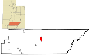
 Location in Garfield County and state of Utah. |
|
| Coordinates: 37°55′28″N 111°25′34″W / 37.92444°N 111.42611°WCoordinates: 37°55′28″N 111°25′34″W / 37.92444°N 111.42611°W | |
| Country | United States |
| State | Utah |
| County | Garfield |
| Settled | c. 1890 |
| Named for | Boulder Mountain |
| Government | |
| • Mayor | Bill Muse |
| • Clerk | Judith Davis |
| Area | |
| • Total | 20.9 sq mi (54.2 km2) |
| • Land | 20.9 sq mi (54.2 km2) |
| • Water | 0.0 sq mi (0.0 km2) |
| Elevation | 6,703 ft (2,043 m) |
| Population (2012) | |
| • Total | 220 |
| • Density | 8.6/sq mi (3.3/km2) |
| Time zone | MST (UTC-7) |
| • Summer (DST) | MDT (UTC-6) |
| ZIP code | 84716 |
| Area code(s) | 435 |
| FIPS code | 49-07470 |
| GNIS feature ID | 1437510 |
Boulder is a town in Garfield County, Utah, United States, 27 miles (44 km) northeast of Escalante on Utah Scenic Byway 12 at its intersection with the Burr Trail. As of the 2010 census, the town population was 226, a modest increase over the 2000 figure of 180.
Boulder, quite isolated until the Civilian Conservation Corps built a road from Escalante, did not get electric power until 1947. The town marks the western terminus of Burr Trail, a mostly paved road that runs eastward through spectacular red rock country to the Waterpocket Fold in Grand Staircase-Escalante National Monument. Boulder is the home of Anasazi Indian State Park.
Boulder is located near Grand Staircase-Escalante National Monument and Capitol Reef National Park.
According to the United States Census Bureau, the town has a total area of 20.9 square miles (54.2 km²), none of which is covered with water. Boulder also has many sandstone formations, such as small mountains and slopes.
According to the Köppen Climate Classification system, Boulder has a semi-arid climate, abbreviated "BSk" on climate maps.
As of the census of 2000, there were 180 people, 65 households, and 41 families residing in the town. The population density was 8.6 people per square mile (3.3/km²). There were 102 housing units at an average density of 4.9 per square mile (1.9/km²). The racial makeup of the town was 96.67% White, 1.11% Asian, 0% African American, 0% Native American, 0% Pacific Islander, 0% from other races, and 2.22% from two or more races. Hispanic or Latino of any race were 1.11% of the population.
...
Wikipedia
