Bostra
|
Bosra بصرى بصرى الشام |
|
|---|---|
| Town | |
| Busra al-Sham | |

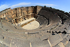
The centre of Bosra
|
|
| Location in Syria | |
| Coordinates: 32°31′N 36°29′E / 32.517°N 36.483°ECoordinates: 32°31′N 36°29′E / 32.517°N 36.483°E | |
| Country |
|
| Governorate | Daraa |
| District | Daraa |
| Subdistrict | Bosra |
| Occupation |
|
| Population (2004) | |
| • Total | 19,683 |
| • Religions |
Sunni Muslim Shia Muslim (minority) |
| Area code(s) | 15 |
| Ancient City of Bosra | |
|---|---|
| Name as inscribed on the World Heritage List | |
 |
|
| Location | Syria |
| Type | Cultural |
| Criteria | i, iii, iv |
| Reference | 22 |
| UNESCO region | Arab States |
| Inscription history | |
| Inscription | 1980 (4th Session) |
Bosra (Arabic: بصرى, translit. Buṣrā, also spelled Bostra, Busrana, Bozrah, Bozra and officially known Busra al-Sham (Arabic: بصرى الشام, translit. Buṣrā al-Shām, Turkish: Busra el-Şam) is a town in southern Syria, administratively belonging to the Daraa District of the Daraa Governorate and geographically being part of the Hauran region.
According to the Syria Central Bureau of Statistics (CBS), Bosra had a population of 19,683 in the 2004 census. It is the administrative center of the nahiyah ("subdistrict") of Bosra which consisted of nine localities with a collective population of 33,839 in 2004. Bosra's inhabitants are predominantly Sunni Muslims, although the town has a small Shia Muslim community.
Bosra has an ancient history and during the Roman era it was a prosperous provincial capital and Metropolitan Archbishopric, under the jurisdiction of Eastern Orthodox Patriarchate of Antioch and All the East. It continued to be administratively important during the Islamic era, but became gradually less prominent during the Ottoman era. It also became a Latin Catholic titular see and the episcopal see of a Melkite Catholic Archeparchy. Today, it is a major archaeological site and has been declared by UNESCO as a World Heritage Site.
...
Wikipedia

