Bosnia
|
Bosnia and Herzegovina
Bosna i Hercegovina
Босна и Херцеговина |
|||||
|---|---|---|---|---|---|
|
|||||
|
Anthem:
Državna himna Bosne i Hercegovine National Anthem of Bosnia and Herzegovina |
|||||
 |
|||||
| Capital and largest city |
Sarajevo 43°52′N 18°25′E / 43.867°N 18.417°E |
||||
| Official languages | None (de jure) Bosnian, Croatian and Serbian (de facto, standard varieties of Serbo-Croatian) |
||||
| Ethnic groups (2013 census) | |||||
| Demonym | |||||
| Government | Federal parliamentary republic |
||||
| Mladen Ivanića | |||||
| Dragan Čovićb Bakir Izetbegovićc |
|||||
| Denis Zvizdić | |||||
| Legislature | Parliamentary Assembly | ||||
| House of Peoples | |||||
| House of Representatives | |||||
| Independence | |||||
| 1154 | |||||
| 1377 | |||||
| 1463 | |||||
| 1831 | |||||
| 1878 | |||||
| 1908 | |||||
| 25 November 1943 | |||||
|
• Republic of BiH & independence from SFRJ
|
1 March 1992 | ||||
|
• Observed
|
6 April 1992 | ||||
| Area | |||||
|
• Total
|
51,197 km2 (19,767 sq mi) (127th) | ||||
|
• Water (%)
|
0.8% | ||||
| Population | |||||
|
• 2013 census
|
3,531,159 | ||||
|
• Density
|
68.97/km2 (178.6/sq mi) | ||||
| GDP (PPP) | 2016 estimate | ||||
|
• Total
|
$41.127 billion | ||||
|
• Per capita
|
$11,647 | ||||
| GDP (nominal) | 2016 estimate | ||||
|
• Total
|
$16.306 billion | ||||
|
• Per capita
|
$4,617.75 | ||||
| Gini (2013) | 36.2 medium |
||||
| HDI (2014) |
high · 85th |
||||
| Currency | Convertible mark (BAM) | ||||
| Time zone | CET (UTC+1) | ||||
|
• Summer (DST)
|
CEST (UTC+2) | ||||
| Date format | dd. mm. yyyy. (CE) | ||||
| Drives on the | right | ||||
| Calling code | 387 | ||||
| ISO 3166 code | BA | ||||
| Internet TLD | .ba | ||||
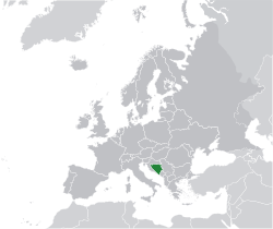
Bosnia and Herzegovina (![]() i/ˈbɒzniə ənd ˌhɛərtsəɡoʊˈviːnə, -ˌhɜːrt-, -ɡə-/ or /ˌhɜːrtsəˈɡɒvᵻnə/;Serbo-Croatian: Bosna i Hercegovina/Боснa и Херцеговина; pronounced [bôsna i xěrt͡seɡoʋina]), sometimes called Bosnia-Herzegovina or Bosnia & Herzegovina, abbreviated BiH or B&H, and, in short, often known informally as Bosnia, is a country in Southeastern Europe located on the Balkan Peninsula. Sarajevo is the capital and largest city. Bordered by Croatia to the north, west, and south; Serbia to the east; Montenegro to the southeast; and the Adriatic Sea to the south, with a coastline about 20 kilometres (12 miles) long surrounding the city of Neum. In the central and eastern interior of the country the geography is mountainous, in the northwest it is moderately hilly, and the northeast is predominantly flatland. The inland is a geographically larger region and has a moderate continental climate, with hot summers and cold and snowy winters. The southern tip of the country has a Mediterranean climate and plain topography.
i/ˈbɒzniə ənd ˌhɛərtsəɡoʊˈviːnə, -ˌhɜːrt-, -ɡə-/ or /ˌhɜːrtsəˈɡɒvᵻnə/;Serbo-Croatian: Bosna i Hercegovina/Боснa и Херцеговина; pronounced [bôsna i xěrt͡seɡoʋina]), sometimes called Bosnia-Herzegovina or Bosnia & Herzegovina, abbreviated BiH or B&H, and, in short, often known informally as Bosnia, is a country in Southeastern Europe located on the Balkan Peninsula. Sarajevo is the capital and largest city. Bordered by Croatia to the north, west, and south; Serbia to the east; Montenegro to the southeast; and the Adriatic Sea to the south, with a coastline about 20 kilometres (12 miles) long surrounding the city of Neum. In the central and eastern interior of the country the geography is mountainous, in the northwest it is moderately hilly, and the northeast is predominantly flatland. The inland is a geographically larger region and has a moderate continental climate, with hot summers and cold and snowy winters. The southern tip of the country has a Mediterranean climate and plain topography.
...
Wikipedia


