Borsele
| Borsele | |||
|---|---|---|---|
| Municipality | |||

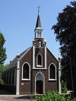
Church in Ovezande
|
|||
|
|||
 Location in Zeeland |
|||
| Coordinates: 51°26′N 3°49′E / 51.433°N 3.817°ECoordinates: 51°26′N 3°49′E / 51.433°N 3.817°E | |||
| Country | Netherlands | ||
| Province | Zeeland | ||
| Government | |||
| • Body | Municipal council | ||
| • Mayor | Jaap Gelok (PvdA) | ||
| Area | |||
| • Total | 194.52 km2 (75.10 sq mi) | ||
| • Land | 141.72 km2 (54.72 sq mi) | ||
| • Water | 52.80 km2 (20.39 sq mi) | ||
| Elevation | 2 m (7 ft) | ||
| Population (May 2014) | |||
| • Total | 22,651 | ||
| • Density | 160/km2 (400/sq mi) | ||
| Demonym(s) | Borsselaar | ||
| Time zone | CET (UTC+1) | ||
| • Summer (DST) | CEST (UTC+2) | ||
| Postcode | 4430–4456 | ||
| Area code | 0113 | ||
| Website | www |
||
Borsele (![]() pronunciation ; Zeelandic: Bossele) is a municipality in the southwestern Netherlands on Zuid-Beveland.
pronunciation ; Zeelandic: Bossele) is a municipality in the southwestern Netherlands on Zuid-Beveland.
The name of the municipality is spelled with a single s; the name of the eponymous village is Borssele, spelled with double s.
The municipality is mainly known for the Borssele Nuclear Power Station and the Central Storage For Radioactive Waste.
Baarland, Borssele, Driewegen, Ellewoutsdijk, 's-Gravenpolder, 's-Heer Abtskerke, 's-Heerenhoek, Heinkenszand, Hoedekenskerke, Kwadendamme, Lewedorp, Nieuwdorp, Nisse, Oudelande and Ovezande.
...
Wikipedia


