Bolivar, Tennessee
| Bolivar, Tennessee | |
|---|---|
| City | |

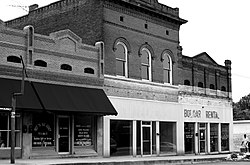
Bolivar Town Square
|
|
 Location in Hardeman County and the state of Tennessee. |
|
| Coordinates: 35°16′N 89°0′W / 35.267°N 89.000°W | |
| Country | United States |
| State | Tennessee |
| County | Hardeman |
| Area | |
| • Total | 8.5 sq mi (22.0 km2) |
| • Land | 8.5 sq mi (22.0 km2) |
| • Water | 0.0 sq mi (0.0 km2) |
| Elevation | 446 ft (136 m) |
| Population (2010) | |
| • Total | 5,417 |
| • Density | 684.4/sq mi (264.3/km2) |
| Time zone | Central (CST) (UTC-6) |
| • Summer (DST) | CDT (UTC-5) |
| ZIP codes | 38008, 38074 |
| Area code(s) | 731 |
| FIPS code | 47-07180 |
| GNIS feature ID | 1269372 |
| Website | www |
Bolivar is a city in Hardeman County, Tennessee, United States. As of the 2010 census, the city population was 5,417. It is the county seat of Hardeman County. The town was named for South American revolutionary leader Simón Bolívar.
Bolivar is served by William L. Whitehurst Field.
The first settlers came to the area between 10,000 - 7,000 BC.
The first European people to come to Hardeman County looking for permanent residence came in 1819-20. They came from middle Tennessee, Virginia, South Carolina, North Carolina and Kentucky. The first town in Hardeman County was established in 1823 on the banks of the Big Hatchie, the Indian name for the river, and was called Hatchie Town. The new site, the county seat, bore the name Hatchie until by Act of the Tennessee State Legislature, on October 18, 1825, it was changed to Bolivar. Bolivar was named for General Simón Bolívar, the South American patriot and liberator.
Hardeman County was officially organized on October 16, 1823, and was named for Thomas Jones Hardeman, a veteran of the War of 1812, who served as the first county court clerk and a commissioner for Bolivar before moving to Texas in 1835.
According to the United States Census Bureau, the city has a total area of 8.5 square miles (22 km2), of which 8.5 square miles (22 km2) is land and 0.12% is water.
As of the census of 2000, there were 5,802 people, 2,161 households, and 1,462 families residing in the city. The population density was 684.4 people per square mile (264.2/km²). There were 2,352 housing units at an average density of 277.4 per square mile (107.1/km²). The racial makeup of the city was 42.33% White, 56.39% African American, 0.07% Native American, 0.50% Asian, 0.02% Pacific Islander, 0.07% from other races, and 0.62% from two or more races. Hispanic or Latino of any race were 0.60% of the population.
...
Wikipedia
