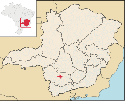
Boa Esperança, Minas Gerais
|
Good Hope Boa Esperança |
|||
|---|---|---|---|
 |
|||
|
|||
| Nickname(s): Furnas City | |||
| Motto: Uma cidade de todos (A City for All) |
|||
 Location of Boa Esperança within the State of Minas Gerais |
|||
| Location of Boa Esperança within Brazil | |||
| Coordinates: 21°05′24″S 45°33′57″W / 21.09000°S 45.56583°WCoordinates: 21°05′24″S 45°33′57″W / 21.09000°S 45.56583°W | |||
| Country | Brazil | ||
| State | Minas Gerais | ||
| Mesoregion | South and southeast of Minas | ||
| Microregion | Varginha | ||
| Government | |||
| • Mayor | Antonio Carlos Vilela (2013–2016) (PT) |
||
| Area | |||
| • Total | 860.669 km2 (332.306 sq mi) | ||
| Elevation | 775 m (2,543 ft) | ||
| Population (2010) | |||
| • Total | 38,509 | ||
| • Density | 45/km2 (120/sq mi) | ||
| Demonym(s) | Esperansense, Dorense | ||
| Time zone | BRT (UTC-3) | ||
| • Summer (DST) | BRST (UTC-2) | ||
| Website | link | ||
Boa Esperança is a Brazilian municipality from the state of Minas Gerais. It is located at a latitude 21º05'24" south and at a longitude 45º33'57" west, being at an altitude of 775 meters. According to the census conducted by IBGE in 2010, its population is 38.509 inhabitants. is a municipality in the Brazilian state of Minas Gerais. The population in 2010 was 38,509 and the area is 860.669 square kilometres (332.306 sq mi). The elevation is 775 metres (2,543 ft). The economy of Boa Esperança is based on coffee plantations and tourism. It is in this municipality Serra da Boa Esperança is found, which became celebrated through song that brings its name, compounded by Lamartine Babo and performed by several singers. Across its territory passes Rio Grande, important to the development of the region.
The municipality of Boa Esperança (English: Good Hope) came up with gold rush of the late 19th century. The first settlement was established in 1778, and in 1804 it was called 'Dores do Pântano (English: Pain Swamp). In 1814 started the construction of the Church, and at that time arose the first coffee plantations, which marked a phase of wealth and progress for the parish. In 1866 the parish was elevated by provincial law to the status of village. On 15 November 1868 the seat of local government was built and the village was elevated by Provincial Law No. 1611 to the status of municipality. In 1957–1958, with the construction of the Furnas Dam and subsequelntly of the Furnas Lake, the town began to grow throughout tourism.
...
Wikipedia


