Bluffdale, Utah
| Bluffdale, Utah | ||
|---|---|---|
| City | ||

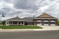
Bluffdale Fire Station in 2013
|
||
|
||
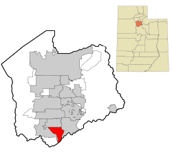
 Location in Salt Lake County and the state of Utah. |
||
 Location of Utah in the United States |
||
| Coordinates: 40°28′24″N 111°56′40″W / 40.47333°N 111.94444°WCoordinates: 40°28′24″N 111°56′40″W / 40.47333°N 111.94444°W | ||
| Country | United States | |
| State | Utah | |
| County | Salt Lake | |
| Founded | 1886 | |
| Named for | Bluffs (high cliffs) and dales (valleys) along the Jordan River | |
| Government | ||
| • Mayor | Derk Timothy | |
| • City Manager | Mark Reid | |
| Area | ||
| • Total | 10.22 sq mi (26.47 km2) | |
| • Land | 10.22 sq mi (26.47 km2) | |
| • Water | 0.0 sq mi (0.0 km2) | |
| Elevation | 4,436 ft (1,352 m) | |
| Population (2012) | ||
| • Total | 7,975 | |
| • Density | 780/sq mi (300/km2) | |
| Time zone | MST (UTC-7) | |
| • Summer (DST) | MDT (UTC-6) | |
| ZIP code | 84065 | |
| Area code(s) | 385, 801 | |
| FIPS code | 49-06810 | |
| GNIS feature ID | 1425844 | |
| Website | bluffdale.com | |
Bluffdale is a city in Salt Lake County in the U.S. state of Utah, located about 20 miles (32 km) south of Salt Lake City. As of the 2010 census, the city population was 7,598.
From 2011 to 2013, the National Security Agency's (NSA) data storage center, the Utah Data Center, was constructed at Camp Williams in Bluffdale. It is approximately 1 million square feet in size. Bluffdale is also home to the Granite Point data center.
Bluffdale, named for its geography of bluffs and dales, was first settled in 1848–1849 when the area was originally part of West Jordan. On July 29, 1858, Orrin Porter Rockwell paid five- hundred dollars to Evan M. Green for sixteen acres of land near to the Crystal Hot Lakes (adjacent to the present Utah State Prison). This land included a hotel with dining facilities, stable, brewery, and pony express station. As the community expanded, the Bluffdale area became part of South Jordan, then Riverton. In 1883 the Bluffdale School Precinct was formed from parts of Herriman, South Jordan and Draper. On August 1, 1886, the Bluffdale Ward of The Church of Jesus Christ of Latter-day Saints was organized with Lewis H. Mousley as Bishop. For a short time the town was called Mousley. There are seven irrigation canals that originate at the Jordan Narrows in the Bluffdale area and serve the Salt Lake Valley. One of the earliest was the Utah and Salt Lake Canal started in 1862. Some of the early buildings included an adobe church, built in 1887–1888, a tithing house, and a three-room schoolhouse constructed in 1893.
According to the United States Census Bureau, the city has a total area of 10.22 square miles (26.47 km²), all of it land. Bluffdale is predominately located in Salt Lake County, though a portion of the city is located in Utah County. Bluffdale shares city borders with Herriman to the west, Riverton to the north, Draper to the east, and Lehi to the south.
...
Wikipedia

