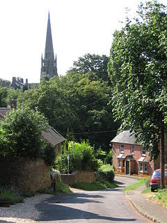
Bloxham
| Bloxham | |
|---|---|
 Part of Bloxham village, with St Mary's church spire in the background |
|
| Bloxham shown within Oxfordshire | |
| Area | 12.72 km2 (4.91 sq mi) |
| Population | 3,374 (2011 Census) |
| • Density | 265/km2 (690/sq mi) |
| OS grid reference | SP4235 |
| Civil parish |
|
| District | |
| Shire county | |
| Region | |
| Country | England |
| Sovereign state | United Kingdom |
| Post town | Banbury |
| Postcode district | OX15 |
| Dialling code | 01295 |
| Police | Thames Valley |
| Fire | Oxfordshire |
| Ambulance | South Central |
| EU Parliament | South East England |
| UK Parliament | |
| Website | Bloxham Parish Council |
Bloxham is a village and civil parish in northern Oxfordshire on the edge of the Cotswolds, about 3 miles (5 km) southwest of Banbury. It is on the edge of a valley and overlooked by Hobb Hill. The village is on the A361 road. The 2011 Census recorded the parish's population as 3,374.
Under Roman rule between the 1st and 5th centuries AD there were several farms and a burial site in the Bloxham area. A poor farming community lived at a site 1⁄2 mile (800 m) west of the present village.
The toponym is derived from the Old English Blocc's Ham (the home of Blocc) from the 6th century, when a Saxon settlement was built on the present site of the village, on the banks of a tributary of the Sor Brook. In 1086 the Domesday Book called the village Blochesham. Its name was subsequently recorded as Blocchesham in 1142, Blokesham in 1216, and finally Bloxham in 1316. In the late Anglo-Saxon era Bloxham was part of a large estate, belonging to the Earl of Mercia, stretching from the boundary with Tadmarton and Wigginton in the west to the River Cherwell. As the caput of a hundred it had been important since at least the time of Edward the Elder.
Around the time of the Norman Conquest of England a group called the Bloxham Feoffees formed. The name, of Anglo-Norman origin, denotes someone invested with a fief, which was often heritable land or property but could be rights or revenue. Comprising between 8 and 16 local yeomen, the Feoffees were responsible for the well-being of the village community. In return for helping the poor and services such as repairing the bridges, they were bequeathed money and land by the Crown. Until the 20th century they continued their village maintenance despite being replaced by a parish council after the Local Government Act 1894. Today they give financial help to Bloxham residents. The Feoffees own land in Grove Road (which is now rented to the Warriner School), the former allotment field in South Newington Road and the Old Court House.
...
Wikipedia

