Blowering Dam
| Blowering Dam | |
|---|---|

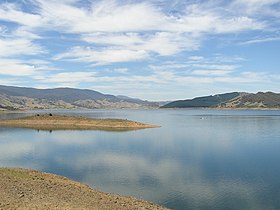
Blowering Dam, in 2006.
|
|
|
Location of the Blowering Dam
in New South Wales |
|
| Country | Australia |
| Location | Snowy Mountains, New South Wales |
| Coordinates | 35°24′05″S 148°14′52″E / 35.40139°S 148.24778°ECoordinates: 35°24′05″S 148°14′52″E / 35.40139°S 148.24778°E |
| Status | Operational |
| Construction began | 1964 |
| Opening date | 1968 |
| Owner(s) | State Water Corporation |
| Dam and spillways | |
| Type of dam | Embankment dam |
| Impounds | Tumut River |
| Height | 114 metres (374 ft) |
| Length | 747 metres (2,451 ft) |
| Dam volume | 8,563 cubic metres (302,400 cu ft) |
| Spillways | 1 |
| Spillway type | Concrete chute |
| Spillway capacity | 2,350 cubic metres per second (83,000 cu ft/s) |
| Reservoir | |
| Creates | Blowering Reservoir |
| Total capacity | 1,628,000 megalitres (57,500×106 cu ft) |
| Catchment area | 1,606 square kilometres (620 sq mi) |
| Surface area | 44.6 square kilometres (17.2 sq mi) |
| Maximum water depth | 91 metres (299 ft) |
| Power station | |
| Operator(s) | Snowy Hydro |
| Commission date | 1969 |
| Hydraulic head | 86.6 metres (284 ft) |
| Turbines | 1 |
| Installed capacity | 80 megawatts (110,000 hp) |
|
Website Blowering Dam at www |
|
The Blowering Dam is a major ungated rock fill with clay core embankment dam with concrete chute spillway across the Tumut River upstream of Tumut in the Snowy Mountains region of New South Wales, Australia. The dam's purpose includes flood mitigation, hydro-power, irrigation, water supply and conservation. The dam is part of the Snowy Mountains Scheme, a vast hydroelectricity and irrigation complex constructed in south-east Australia between 1949 and 1974 and now run by Snowy Hydro. The impounded reservoir is called Blowering Reservoir.
Commenced in 1964, completed in 1968, and upgraded in 2010, the Blowering Dam is a major ungated dam, located approximately 13 kilometres (8.1 mi) south of Tumut. The dam was built by consortium including Morrison, Knudsen, Utah and Mcdonald on behalf of the New South Wales Department of Land and Water Conservation for town water supplies, river flows and domestic requirements, irrigated agriculture, industry, flood mitigation and environmental flows. Together with releases from Burrinjuck Dam, on the Murrumbidgee River, Blowering Dam also provides a regulated flow of water for the Coleambally and Murrumbidgee Irrigation Areas.
The dam wall constructed with 8,563 cubic metres (302,400 cu ft) of rock fill with clay core is 112 metres (367 ft) high and 808 metres (2,651 ft) long. The maximum water depth is 91 metres (299 ft) and at 100% capacity the dam wall holds back 1,628,000 megalitres (57,500×106 cu ft) of water at 379 metres (1,243 ft) AHD. The surface area of the Blowering Reservoir is 44.6 square kilometres (17.2 sq mi) and the catchment area is 1,606 square kilometres (620 sq mi). The uncontrolled concrete chute spillway is capable of discharging 2,350 cubic metres per second (83,000 cu ft/s).
...
Wikipedia

