Blount Township, Vermilion County, Illinois
| Blount Township | |
|---|---|
| Township | |

Lake at Kennekuk County Park, in the western part of the township
|
|
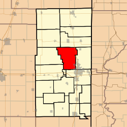
 Location in Vermilion County |
|
| Coordinates: 40°12′50″N 87°42′09″W / 40.21389°N 87.70250°WCoordinates: 40°12′50″N 87°42′09″W / 40.21389°N 87.70250°W | |
| Country | United States |
| State | Illinois |
| County | Vermilion |
| Created | 1856 |
| Area | |
| • Total | 51.72 sq mi (134.0 km2) |
| • Land | 51.36 sq mi (133.0 km2) |
| • Water | 0.36 sq mi (0.9 km2) 0.70% |
| Elevation | 679 ft (207 m) |
| Population (2010) | |
| • Total | 3,428 |
| • Density | 66.7/sq mi (25.8/km2) |
| Time zone | CST (UTC-6) |
| • Summer (DST) | CDT (UTC-5) |
| ZIP codes | 61811, 61831, 61832, 61834, 61858, 61865 |
| Area code(s) | 217 |
| FIPS code | 17-06678 |
| GNIS feature ID | 0428686 |
Blount Township is a township in Vermilion County, Illinois, USA. As of the 2010 census, its population was 3,428 and it contained 1,475 housing units.
Blount Township was established in 1856 from portions of Newell and Pilot townships. It was originally named after John C. Frémont, the Republican candidate for president that year. Democrats objected, and the township was named after early settler Abraham Blount.
According to the 2010 census, the township has a total area of 51.72 square miles (134.0 km2), of which 51.36 square miles (133.0 km2) (or 99.30%) is land and 0.36 square miles (0.93 km2) (or 0.70%) is water. The northwestern portion of the county seat of Danville extends into the southeast portion of the township, as does a portion of Lake Vermilion.
The township contains eleven cemeteries: Bethel, Dodson, Fairchild, Gordon, Higginsville, Johnson, New Salem, Newell Grove, Pentecost, Porter, Snider and Thurman.
...
Wikipedia
