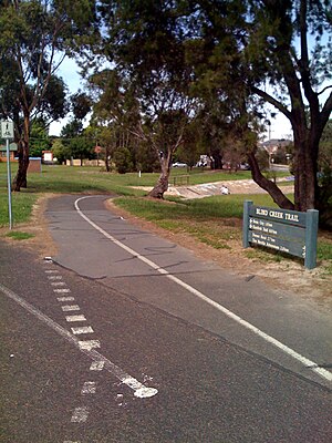
Blind Creek Trail
| Blind Creek Trail | |
|---|---|

The Blind Creek Trail near Scoresby Road in Ferntree Gully.
|
|
| Length | 11.5 km |
| Location | Melbourne, Victoria, Australia |
| Cycling details | |
| Trail difficulty | Easy |
| Hazards | Some blind corners, a handful of road crossings, damaged path surface in some areas |
| Surface | Mostly asphalt, minor concrete sections |
| Hills | Minor hill near the Dandenong Creek Trail |
| Connecting transport | |
| Parking | Shepherd Road, Glen Waverley Nortons Park, Wantirna South Collier Reserve, Wantirna South Westfield Knox, Wantirna South Lewis Park, Wantirna South Fairpark Reserve, Ferntree Gully Boronia Tennis Club, Ferntree Gully Tim Neville Arboretium, Ferntree Gully |
|
Blind Creek Trail route guide (major intersections only) Start point at37°53′07″S 145°11′46″E / 37.885239°S 145.196011°E End point at 37°52′20″S 145°17′24″E / 37.872150°S 145.290132°E. (distances in kilometres)
| |||||||||||||||||||||||||||||||||||||||||||||||||||||||||||||||||||||||||||||||||||||||||||||||||||||||||||||||||||||||||||||||||||||||||||||||||||||||||||||||||||||||||||||||||||||||||||||||||||||||||||
|---|---|---|---|---|---|---|---|---|---|---|---|---|---|---|---|---|---|---|---|---|---|---|---|---|---|---|---|---|---|---|---|---|---|---|---|---|---|---|---|---|---|---|---|---|---|---|---|---|---|---|---|---|---|---|---|---|---|---|---|---|---|---|---|---|---|---|---|---|---|---|---|---|---|---|---|---|---|---|---|---|---|---|---|---|---|---|---|---|---|---|---|---|---|---|---|---|---|---|---|---|---|---|---|---|---|---|---|---|---|---|---|---|---|---|---|---|---|---|---|---|---|---|---|---|---|---|---|---|---|---|---|---|---|---|---|---|---|---|---|---|---|---|---|---|---|---|---|---|---|---|---|---|---|---|---|---|---|---|---|---|---|---|---|---|---|---|---|---|---|---|---|---|---|---|---|---|---|---|---|---|---|---|---|---|---|---|---|---|---|---|---|---|---|---|---|---|---|---|---|---|---|---|---|
