Blackwater, Missouri
| Blackwater, Missouri | |
|---|---|
| City | |

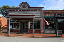
Blackwater City Hall
|
|
 Location of Blackwater, Missouri |
|
| Coordinates: 38°58′46″N 92°59′27″W / 38.97944°N 92.99083°WCoordinates: 38°58′46″N 92°59′27″W / 38.97944°N 92.99083°W | |
| Country | United States |
| State | Missouri |
| County | Cooper |
| Area | |
| • Total | 0.33 sq mi (0.85 km2) |
| • Land | 0.33 sq mi (0.85 km2) |
| • Water | 0 sq mi (0 km2) |
| Elevation | 630 ft (192 m) |
| Population (2010) | |
| • Total | 162 |
| • Estimate (2012) | 162 |
| • Density | 490.9/sq mi (189.5/km2) |
| Time zone | Central (CST) (UTC-6) |
| • Summer (DST) | CDT (UTC-5) |
| ZIP code | 65322 |
| Area code(s) | 660 |
| FIPS code | 29-06148 |
| GNIS feature ID | 0714334 |
Blackwater is a city in Cooper County, Missouri, along the Blackwater River, from which it takes its name. The population was 162 at the 2010 census.
Many parts of Blackwater's commercial and residential districts are listed on the National Register of Historic Places.
Blackwater was platted in 1887, although it had long functioned as a trading point. A post office called Blackwater has been in operation since 1873.
Blackwater Commercial Historic District, Blackwater Residential Historic District, and Imhoff Archeological Site are listed on the National Register of Historic Places.
Blackwater is located at 38°58′46″N 92°59′27″W / 38.97944°N 92.99083°W (38.979403, -92.990871).
According to the United States Census Bureau, the city has a total area of 0.33 square miles (0.85 km2), all of it land.
As of the census of 2010, there were 162 people, 64 households, and 45 families residing in the city. The population density was 490.9 inhabitants per square mile (189.5/km2). There were 87 housing units at an average density of 263.6 per square mile (101.8/km2). The racial makeup of the city was 95.1% White, 1.9% African American, 0.6% Native American, and 2.5% from two or more races. Hispanic or Latino of any race were 1.9% of the population.
...
Wikipedia
