Blacko
| Blacko | |
|---|---|
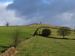
 A view of Blacko Tower taken from the top of the village in early winter |
|
| Blacko shown within Lancashire | |
| Population | 672 (2011) |
| OS grid reference | SD856415 |
| Civil parish |
|
| District | |
| Shire county | |
| Region | |
| Country | England |
| Sovereign state | United Kingdom |
| Post town | NELSON |
| Postcode district | BB9 |
| Dialling code | 01282 |
| Police | Lancashire |
| Fire | Lancashire |
| Ambulance | North West |
| EU Parliament | North West England |
| UK Parliament | |
Blacko is a village and civil parish in the Pendle district of Lancashire, England. Before local government reorganisation in 1974 the village lay on the border with the West Riding of Yorkshire. The parish has a population of 672. The village is on the old turnpike road from Nelson to Gisburn (A682). The village enjoys views towards Boulsworth Hill to its southeast, the former cotton town of Nelson, about two miles to its south and Pendle Hill to its west across the valley of Pendle Water.
The parish adjoins the Pendle parishes of Middop, Bracewell and Brogden, Salterforth, Foulridge, Colne, Barrowford, Roughlee Booth and Barley-with-Wheatley Booth. Parts of the parish, west of the village are included in the Forest of Bowland Area of Outstanding Natural Beauty (AONB).
Overlooking the village is Stansfield Tower (also known as Blacko Tower), which was built around 1890. A local grocer, Jonathan Stansfield, built this circular rough stone tower to provide himself with a view over Ribblesdale from the top, but the height fell somewhat short. A Bronze Age axe, believed to be 3,500 years old, was found near the tower in 1952.
The village has won the small village category of the Lancashire Best Kept Village competition in 2002 and 07, and the champion village category in 2011, 13, and 14.
...
Wikipedia

