Black Mountain (Belfast)
| Black Mountain | |
|---|---|
| Sliabh Dubh/an Cnoc Dubh | |

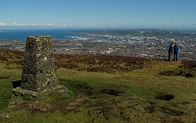
Triangulation pillar on Black Mountain
|
|
| Highest point | |
| Elevation | 1,275 ft (389 m) |
| Coordinates | 54°36′N 5°59′W / 54.6°N 5.98°WCoordinates: 54°36′N 5°59′W / 54.6°N 5.98°W |
| Geography | |
| Location | overlooking Belfast, Northern Ireland |
| OSI/OSNI grid | J266741 |
| Topo map | OSNI Discoverer 15 |
| Geology | |
| Mountain type | basalt |
Black Mountain is a large hill which overlooks the city of Belfast, Northern Ireland.
The mountain is one of the most prominent features of the city, towering above most of west Belfast. It reaches a height of 1,275 ft and is composed of basalt with limestone underneath, as is Cavehill further north. There have been flint finds in the area, which also contains raths, deserted farms and overgrown paths joining the fields and homesteads and trails scattered over the mountain. On a clear day there are views of Strangford Lough, the Mournes and the Sperrins, as well as Scotland and Donegal.
There is a well-known field located on the Black Mountain, this is called the 'Hatchet Field', it is so called because it is in the shape of an old-fashioned hatchet. Also located on top of the mountain (Wolfe Hill) is a police barracks belonging to the Police Service of Northern Ireland and the Black Mountain transmitting station which is a broadcasting and telecommunications facility. One way to proceed up the mountain is by the 'Mountain Loney,' a path leading up the mountain and across the 'Hatchet Field'. This path is found adjacent to Dermot Hill, a housing estate in west Belfast, and is popular with walkers and tourists.
For many years people have lobbied for the preservation of the Belfast Hills, hoping to bring an end to many years of quarrying. The quarry is steep and deeply excavated and the basalt from it is used mostly for road stone.
...
Wikipedia

