Bjugn
| Bjugn kommune | |||
|---|---|---|---|
| Municipality | |||
 |
|||
|
|||
 Bjugn within Sør-Trøndelag |
|||
| Coordinates: 63°48′24″N 9°53′53″E / 63.80667°N 9.89806°ECoordinates: 63°48′24″N 9°53′53″E / 63.80667°N 9.89806°E | |||
| Country | Norway | ||
| County | Sør-Trøndelag | ||
| District | Fosen | ||
| Administrative centre | Botngård | ||
| Government | |||
| • Mayor (1999) | Arnfinn Astad (Ap) | ||
| Area | |||
| • Total | 383.80 km2 (148.19 sq mi) | ||
| • Land | 355.83 km2 (137.39 sq mi) | ||
| • Water | 27.97 km2 (10.80 sq mi) | ||
| Area rank | 243 in Norway | ||
| Population (2010) | |||
| • Total | 4,548 | ||
| • Rank | 199 in Norway | ||
| • Density | 12.8/km2 (33/sq mi) | ||
| • Change (10 years) | -3.2 % | ||
| Demonym(s) | Bjugning | ||
| Time zone | CET (UTC+1) | ||
| • Summer (DST) | CEST (UTC+2) | ||
| ISO 3166 code | NO-1627 | ||
| Official language form | Bokmål | ||
| Website | www |
||
|
|
|||
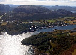
Bjugn is a municipality in Sør-Trøndelag county, Norway. It is part of the Fosen region. The village of Botngård is the administrative centre of Bjugn municipality. Other villages in Bjugn include Høybakken, Jøssund, Lysøysundet, Nes, Oksvoll, and Vallersund.
The municipality of Bjugn was established in 1853 when it was separated from the large municipality of Ørland. Initially, Bjugn had 2,903 residents. On 26 March 1870, a royal resolution moved an unpopulated part of Åfjord to Bjugn. On 1 January 1899, the western district of Nes (population: 1,285) and the southern district of Skjørn (population: 2,166) were separated from Bjugn. This left Bjugn with 1,256. On 1 January 1964, Nes, Jøssund, and the northern part of Stjørna were all merged with Bjugn to create a new, larger municipality of Bjugn. The population of Bjugn then increased from 1,240 to 4,940. Bjugn was on the Robek-list in 2015.
The Old Norse form of the name was (also) Bjugn. The name is derived from bjúgr which means "bent", probably referring to the bent form of the local fjord, the Bjugnfjorden.
...
Wikipedia


