Bjelasnica
| Bjelašnica | |
|---|---|

The ski resort at Bjelašnica
|
|
| Highest point | |
| Elevation | 2,067 m (6,781 ft) |
| Coordinates | 43°42′14″N 18°15′25″E / 43.704°N 18.257°ECoordinates: 43°42′14″N 18°15′25″E / 43.704°N 18.257°E |
| Geography | |
| Location |
|
| Parent range | Dinaric Alps |
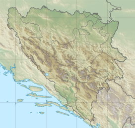
Bjelašnica (pronounced [bjělaːʃnit͡sa]) is a mountain in central Bosnia and Herzegovina. It is found directly to the southwest of Sarajevo, bordering Mt. Igman. Bjelašnica's tallest peak, by which the whole mountain group got its name, rises to an elevation of 2067 meters (6782 feet). Other notable peaks are Krvavac (2061 m), Mali Vlahinja (2055 m), and Hranisava (1964 m). The Bjelašnica range is bordered by the Rakitnica in the south, the Neretva in the west, Mt Igman in the north-east and Mt Ivan in the north-west. Only at 20 minutes distance of Sarajevo, it is a popular tourist attraction for hiking and skiing.
Bjelašnica has been, in certain areas, the site of extensive combat during the 1992-'95 Siege of Sarajevo and particular areas pose a high mine risk. There are numerous trails set up and maintained by local mountain clubs that lead to the bald peaks higher up. The mountain is also popular with mountain bikers and has become recently a frequent base for paragliders.
The mountain's name stems from the root bijel, which means "white".
Geologically, Bjelašnica is part of the Dinaric Alps and formed largely of secondary and tertiary sedimentary rock, mostly Limestone and Dolomite.
The white snow cupola of Bjelasnica is a familiar sight from the higher points in Sarajevo in the period from mid October until early June. Bjelašnica's base is largely forested - mixed forest, mostly beech - however there are no trees above the 1500 meter (4921') tree line.
Bjelašnica summit is easily recognized from the distance by the structures that have been erected on top of it. After the Austro-Hungarian Empire occupied Bosnia following the Congress of Berlin in 1878 the Austrians installed almost immediately the first meteorological station on the summit in 1878, creating the first meteorological station in the whole area of the Balkans. This structure was replaced in 1894 by an - at that time - very advanced meteorological observatory with an all-year around manning. The observatory is still there, has been repaired of the damage sustained during the last war, and still functions as an important chain-link in the meteorological survey of the Balkans. The communications Centre with its landmark tower that used to stand next to the observatory was destroyed in 1993. The sad remains of the broken tower were removed in 2006.
...
Wikipedia

