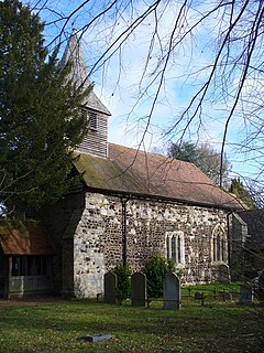
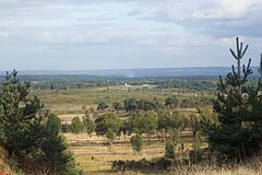
Bisley Camp
| Bisley | |
|---|---|
 St John the Baptist Church |
|
 Bisley Camp |
|
| Bisley shown within Surrey | |
| Area | 3.66 km2 (1.41 sq mi) |
| Population | 3,965 (Civil Parish) |
| • Density | 1,083/km2 (2,800/sq mi) |
| OS grid reference | SU9560 |
| Civil parish |
|
| District | |
| Shire county | |
| Region | |
| Country | England |
| Sovereign state | United Kingdom |
| Post town | Woking |
| Postcode district | GU24 |
| Dialling code | 01483 |
| Police | Surrey |
| Fire | Surrey |
| Ambulance | South East Coast |
| EU Parliament | South East England |
| UK Parliament | |
Bisley /ˈbɪzliː/ is a village and civil parish in the borough of Surrey Heath in Surrey, England. It is centred 3.4 miles (5.5 km) west of Woking. Of medieval creation, Bisley neighbours 19th century West End, centred 900 metres north, across the Windle Brook. According to the 2011 Census, the population was 3,965, which is largely within a focal area with the surrounding green and heather-and-gorse heath buffer land lightly populated, in contrast to Knaphill which is contiguous to Woking, 1 mile (1.6 km) east and is suburban to Woking.
Much of the west of the parish is covered by higher acidic heath, which is owned and used or leased by the Ministry of Defence and is noted for its rifle shooting ranges. The National Shooting Centre, the headquarters of the National Rifle Association of the United Kingdom, is within the historic bounds. Other large buildings are Coldingley men's prison and the former factory of Bisley Office Furniture, a large office furniture manufacturer.
The name 'Bisley' was first recorded in the 10th century as 'Busseleghe'. Its manor was from earliest written records under the feudal lordship of Chertsey Abbey as part of Godley Hundred. It is derived from the old English words 'Bysc', meaning bushes, and 'Leah', a clearing. Therefore, it means clearing where bushes grow or in the bushes. The versions recorded in the 13th century were Busheley and Bussley, from such Westminster and Lambeth Palace rolls as the Assize Rolls.
...
Wikipedia

