Bird Island, Algoa Bay
| Algoa Bay Algoabaai |
|
|---|---|

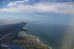
Algoa Bay with Port Elizabeth in the foreground
|
|
| Coordinates | 33°50′S 25°50′E / 33.833°S 25.833°ECoordinates: 33°50′S 25°50′E / 33.833°S 25.833°E |
| Ocean/sea sources | Southern Indian Ocean |
| Basin countries | South Africa |
| Islands |
St Croix Islands, Bird Islands |
| Settlements | Port Elizabeth, Coega |
Algoa Bay is a bay in the Eastern Cape, South Africa. It is located in the east coast, 425 miles (683 kilometres) east of the Cape of Good Hope.
Algoa Bay is bounded in the west by Cape Recife and in the east by Cape Padrone. The bay is up to 436 m (1,430 ft) deep. The harbour city of Port Elizabeth is situated adjacent to the bay, as is the new Coega deep water port facility.
The Portuguese explorer Bartolomeu Dias was the first European to reach Algoa Bay in 1488, where he planted a wooden cross on a small island now called St Croix or Santa Cruz island. He gave the bay a name meaning "Bay of the Rock", which was changed in Portugal to Bahia de Lagoa or Bay of the Lagoon, and which eventually became Algoa Bay.
Joshua Slocum talks about Algoa Bay in his book 'Sailing Alone Around the World':
Nautical charts of the bay caution mariners that "projectiles and badly corroded mustard gas containers have been found in the area between Cape St Francis and Bird Island out to depths of 400 m (1,300 ft). Trawlers should exercise the greatest caution."
The chemical weapons were dumped in the bay in the aftermath of World War II. During that conflict, Port Elizabeth was used as a research, manufacturing and storage site for Allied poison gas. The condition of the canisters and projectiles are not currently known.
The metropolitan municipality of Nelson Mandela Bay, which includes Port Elizabeth, is located on the western shore of Algoa Bay.
The bay contains six named islands in two groups of three that according to BirdLife International “are of considerable importance as they are the only islands along a 1,777 km (1,104 mi) stretch of coastline between Cape Agulhas and Inhaca Island in Mozambique." The combined surface area of these islands is said to be 40 ha (99 acres).
...
Wikipedia

